
Woodward Valley Trail
Hike the Sky–Woodward Valley–Fire Lane Loop the Park Service's write-up
4-6 Hours · no dogs · season <h2>Winter</h2> <p>The heaviest rainfall occurs in the winter months. Come prepared for rain and drizzle to possibly last for several days. In between winter rains, it is often sunny, calm, and cool.</p> <h2>Spring</h2> <p>Most spring days are windy. Expect cool temperatures in March. By late May and early June, temperatures can be quite pleasant.</p> <h2>Summer</h2> <p>Although there is very little rain during summer months, there is often dense fog, which tends to burn off by mid-day. Afternoons are often sunny and warm to hot with a light breeze.</p> <h2>Fall</h2> <p>Point Reyes experience some of the clearest days in late September, October, and early November. The occasional storm will start rolling through in late October, bringing clouds, wind, and rain. The strongest winds occur in November and December during occasional southerly gales.</p>
Start Sky Trailhead along Limantour Road, Point Reyes National Seashore
The Sky Trailhead Parking Lot and the Sky Trail from the trailhead to Sky Campground will be closed from Wednesday, September 18, 2024, through Wednesday, October 2, 2024, for resurfacing and trailwork. The parking lot and trailhead will be fully closed with no overnight parking allowed to accommodate staging equipment and materials. While work is performed on Sky Trail, equestrians and bicyclists must use alternate routes and hikers should also seek different paths. Visitors should also expect to see large trucks on Limatour Road and staging at the pullout across from the Sky Trailhead Parking Lot. Although the trailhead will be closed to parking for the duration of the project, the Sky Trail will be open to hikers on weekends.
-->
Distance : 9.5 miles (15.3 km), strenuous
Descend from forested Inverness Ridge through coastal scrub to the ocean. However, it's a steep return through the forest back to the trailhead.
This hike is mostly within the Phillip Burton Wilderness . Much of this area was burned in the 1995 Vision Fire and, again, by the 2020 Woodward Fire , which was ignited by lightning strikes in August of 2020.
Start at the Sky Trailhead , which is located along Limantour Road. Follow the northern section of the Sky Trail, which has some limited views of the ocean, through the woods for 2.6 miles (4.2 km) to the Woodward Valley Trail. Along the way, you'll pass by the junctions for Fire Lane Trail, Horse Trail, Mount Wittenberg Trail, and Meadow Trail, as well as Sky Campground . Vault toilets and potable water are available along the Sky Trail at the campground, which is 1.3 miles from the trailhead.
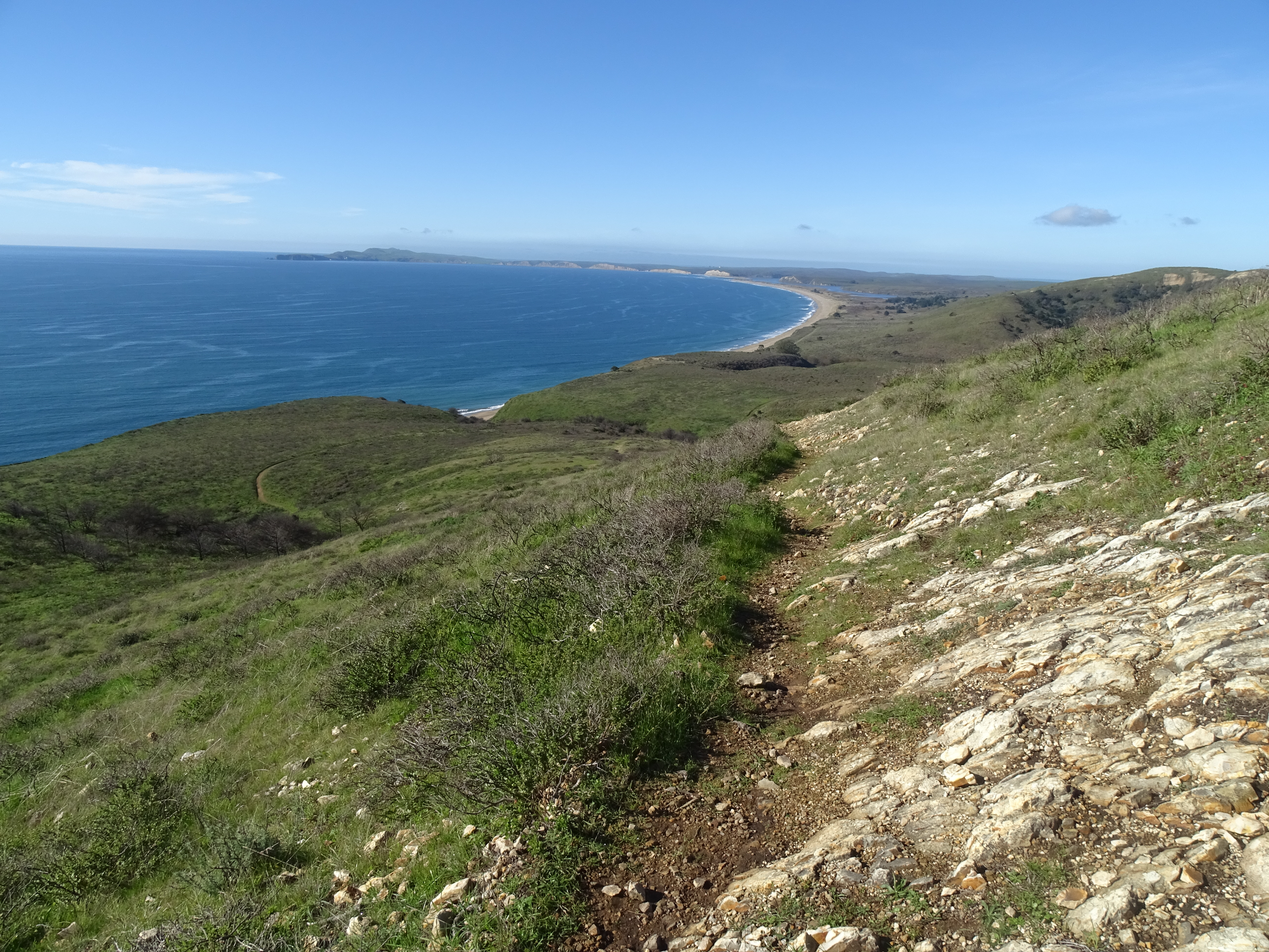
Turn right (west) on to the Woodward Valley Trail, which was one of the lushest, greenest trails in the park before the Woodward Fire. The Woodward Valley Trail descends about 800 feet (~240 meters) over a distance of 2.0 miles (3.2 km) before intersecting with the Coast Trail. Open ocean views are plentiful along the last 0.5 miles (0.8 km) of the Woodward Valley Trail as you pass through coastal grasslands intermixed with some coastal scrub.
Turn right on to the Coast Trail and follow it 0.8 miles (1.3 km) north to Coast Campground . Vault toilets and potable water are available at Coast Campground, and, just north of site 8, a trail leads down to Santa Maria Beach.
To continue with your hike, follow the Coast Trail north from the campground for 0.1 mile (180 meters) to its junction with Fire Lane Trail. Turn right (north) on to the Fire Lane Trail and begin your ascent through coastal scrub to return to the ridge crest. Be sure to turn around every now and then to see if any views of Drakes Bay have become available as you climb.
After 1 mile (1.6 km), bear right to stay on the Fire Lane Trail at its junction with the more heavily traveled Laguna Trail. This northern leg of the Fire Lane Trail will ascend about 600 feet (180 meters) over a distance of 2.3 miles (3.7 km) as it passes from coastal scrub habitat into increasingly denser forest. At its junction with the Sky Trail, turn left and return in 0.8 miles (1.3 km) to the Sky Trailhead.
This route description alone is not a substitute for a trail map. Print out the Point Reyes National Seashore's South District trail map (3,422 KB PDF) before your visit, or pick one up at the Bear Valley Visitor Center on your way.
Always check current conditions before heading out into the park and familiarize yourself with park regulations . Please practice Leave No Trace principles.
Visit the park's Hiking at Point Reyes National Seashore page for hiking tips and information about trail etiquette and safety.
Visit the park's Trail Advisories and Closures page for current information about closed trails, trails blocked by trees, or other temporary hazards or advisories.
Pets Pets are prohibited on the Sky, Woodward Valley, Coast, and Fire Lane trails. Visit the park's Pets page to learn where pets are welcome at Point Reyes National Seashore.
Accessibility The Sky Trail is an old ranch road and its northern 1.4 miles (2.2 km) is maintained as a service road for NPS vehicles to drive to Sky Campground. So, this section of the route tends to be at least 8 feet (2.4 meters) wide with a substrate of dirt and gravel. The Sky Trail from its trailhead to Sky Campground is open to bicycles, strollers, and other wheeled devices. But, since this section has a change in elevation of about 350 feet (106 meters), it may be challenging for someone in a wheelchair without assistance. The other sections of trail along this hike also follow the routes of old ranch roads, but these sections are not maintained as roadways and have largely become single-track trails that may be only a two feet (60 cm) wide in places. The Woodward Valley Trail and the Fire Lane Trail have changes in elevation of roughly 900 feet (270 meters) each and are oftentimes quite steep. Wheeled devices, such as bicycles and strollers, are prohibited on these other trails. Wheelchairs are permitted on these other trails, but none of these trails meet the criteria for being accessible. The vault toilets at Sky and Coast Campgrounds do not meet accessibility standards.
Hike the Woodward Valley Loop the Park Service's write-up
6-7 Hours · no dogs · season <h2>Winter</h2> <p>The heaviest rainfall occurs in the winter months. Come prepared for rain and drizzle to possibly last for several days. In between winter rains, it is often sunny, calm, and cool.</p> <h2>Spring</h2> <p>Most spring days are windy. Expect cool temperatures in March. By late May and early June, temperatures can be quite pleasant.</p> <h2>Summer</h2> <p>Although there is very little rain during summer months, there is often dense fog, which tends to burn off by mid-day. Afternoons are often sunny and warm to hot with a light breeze.</p> <h2>Fall</h2> <p>Point Reyes experience some of the clearest days in late September, October, and early November. The occasional storm will start rolling through in late October, bringing clouds, wind, and rain. The strongest winds occur in November and December during occasional southerly gales.</p>
Start Bear Valley Trailhead, Point Reyes National Seashore
Distance : ~13 miles (21 km), strenuous
Travel from forest to tidepools on this ambitious walk through the central part of the Phillip Burton Wilderness . This trail includes beautiful forest and spectacular coastal hiking with sweeping ocean views. Much of this area through which this route passes was burned in the Woodward Fire , which was started by lightning strikes in August of 2020.
Start at the Bear Valley Trailhead and follow the relatively flat Bear Valley Trail south. A short distance beyond a sign indicating you are entering the Phillip Burton Wilderness, you will get to choose between two routes that will lead you to the Sky Trail along the crest of Inverness Ridge.
Turn right on to the Mount Wittenberg Trail 0.2 miles (0.3 km) from the trailhead if you want a more strenuous ascent of about 1,130 feet (~340 m) over a distance of 1.8 miles (2.9 km). While the Woodward Fire burned along most of the length of the Mount Wittenberg Trail, it primarily burned in the understory and left most of the canopy of the Douglas fir forest intact. As a result, there are very few far-reaching views from this trail until you reach the ridge crest. Remain on the Mount Wittenberg Trail at the Z Ranch Trail junction, which is located at the highest point along this route with an elevation of 1270 feet (385 m).* From the crest of Inverness Ridge along the western 0.4 mile-long (0.6-kilometer-long) leg of the Mount Wittenberg Trail, you may be rewarded (weather dependent) with views looking west across the peninsula to the Pacific Ocean. The Mount Wittenberg Trail intersects with the Sky Trail 0.4 miles (0.6 km) beyond the Z Ranch Trail junction and 2.4 miles (3.8 km) from the Bear Valley Trailhead.
*From Mount Wittenberg-Z Ranch Trail junction, the 0.3-mile-long (0.5-kilometer-long) Mount Wittenberg Summit Trail leads, as its name suggests, to the summit of Mount Wittenberg (elevation 1407 feet (426 m). The once unobstructed views from near the summit have, since 2000, become obstructed by dense Douglas fir thickets that sprouted shortly after the 1995 Vision Fire . While the 2020 Woodward Fire burned through much of the forest around Mount Wittenberg, the view-obstructing Douglas fir thickets were largely left unscathed. So, without being rewarded with views for their effort, many hikers pass on ascending the Mount Wittenberg Summit Trail.
Turn right on to the Meadow Trail 0.8 miles (1.3 km) from the trailhead if you want a slightly easier climb over Inverness Ridge. Similar to the Mount Wittenberg Trail, the Woodward Fire mostly impacted the understory of the forest along the Meadow Trail. While the trail does pass through a fairly large meadow (after which the trail was named), views from the meadow are of forested hillsides less than a mile distant. The Meadow Trail ascends about 840 feet (~255 m) over a distance of 1.6 miles (2.6 km) before intersecting with the Sky Trail 2.4 miles (3.8 km) from the Bear Valley Trailhead. The elevation at this intersection is ~1080 feet (~327 m).
Both the Mount Wittenberg Trail and the Meadow Trail intersect the Sky Trail at the same large trail junction. Turn left (south) on to the Sky Trail and follow it for 0.8 miles (1.3 km) to its junction with the Woodward Valley Trail. Once hemmed in by a ~six-foot-tall (~two-meter-tall) hedge of huckleberry bushes, the Woodward Fire cleared out most of the shrubs and a lot of the lower branches of the trees in this area so that this section of trail feels a bit more open than it did before 2020.
Turn right (west) on to the Woodward Valley Trail, which was one of the lushest, greenest trails in the park before the Woodward Fire. The Woodward Valley Trail descends about 800 feet (~240 meters) over a distance of 2.0 miles (3.2 km) before intersecting with the Coast Trail, where you will turn left/south. Open ocean views are plentiful along the last 0.5 miles (0.8 km) of the Woodward Valley Trail and along the length of the Coast Trail as you pass through coastal grasslands intermixed with some coastal scrub.
The Sculptured Beach Trail branches off after 0.5 miles (0.8 km), leading down to Sculptured Beach , where there are tidepools exposed at low tides. A second location to descend to a beach occurs 2.5 miles (4 km) later when you reach the Kelham Beach Trail junction. The Sculptured Beach and Kelham Beach Trails are indefinitely closed due to storm damage.
Continuing south on the Coast Trail for another 0.9 miles (1.5 km ) brings you to the Coast-Bear Valley Trail junction. Turn left on to the Bear Valley Trail and follow it 4 miles (6.4 km) east and north back to the Bear Valley Trailhead parking lot. The Bear Valley Trail has a gentle grade as it first follows Coast Creek to Divide Meadow and then gradually descends along Bear Valley Creek for the final 1.6 miles (2.6 km) of this hike. Aside from the large meadow at Divide Meadow, the trail passes through a beautiful forest of buckeyes, oaks, and Douglas firs.
Restrooms and water are available at the Bear Valley Trailhead parking lot. Otherwise, there are no other facilities along this route until you reach Divide Meadow, at which there are vault toilets, but no potable water.
This route description alone is not a substitute for a trail map. Print out the Point Reyes National Seashore's South District trail map (3,422 KB PDF) before your visit, or pick one up at the Bear Valley Visitor Center on your way.
Always check current conditions before heading out into the park and familiarize yourself with park regulations . Please practice Leave No Trace principles.
Visit the park's Hiking at Point Reyes National Seashore page for hiking tips and information about trail etiquette and safety.
Visit the park's Trail Advisories and Closures page for current information about closed trails, trails blocked by trees, or other temporary hazards or advisories.
Pets Pets are prohibited on all of the trails that are described on this page. Visit the park's Pets page to learn where pets are welcome at Point Reyes National Seashore.
Accessibility The Bear Valley Trail is wide, mostly flat, and has a substrate of dirt and gravel. The other trails described on this page vary in width from two to six feet (0.6 to 1.8 meters) and have surfaces of mostly compacted dirt that may be rutted and have exposed roots and rocks in places.The total elevation change from Bear Valley to the crest of Inverness Ridge is about 1200 feet (360 meters) over a distance of 1.6 to 1.8 miles (2.6 to 2.9 km), depending on which route one follows. The vault toilet building at Divide Meadow on the Bear Valley trail does not meet accessibility standards.