
Abbotts Lagoon Trail
Trailhead Abbotts Lagoon Trailhead 79 ft Drive there
Hike the Abbotts Lagoon Trail to the Footbridge the Park Service's write-up
40-75 Minutes · no dogs · season <h2>Winter</h2> <p>The heaviest rainfall occurs in the winter months. Come prepared for rain and drizzle to possibly last for several days. In between winter rains, it is often sunny, calm, and cool.</p> <h2>Spring</h2> <p>Most spring days are windy and the Abbotts Lagoon area frequently experiences strong breezes. Expect cool temperatures in March. By late May and early June, temperatures can be quite pleasant, even warm.</p> <h2>Summer</h2> <p>Although there is very little rain during summer months, there is often dense fog throughout the day in July, August and September with temperatures often 20 degrees cooler than at Bear Valley.</p> <h2>Fall</h2> <p>The coastal areas of Point Reyes experience some of the clearest days in late September, October and early November. The occasional storm will start rolling through in late October, bringing clouds, wind, and rain. The strongest winds occur in November and December during occasional southerly gales.</p>
Start Abbotts Lagoon Trailhead, Point Reyes National Seashore
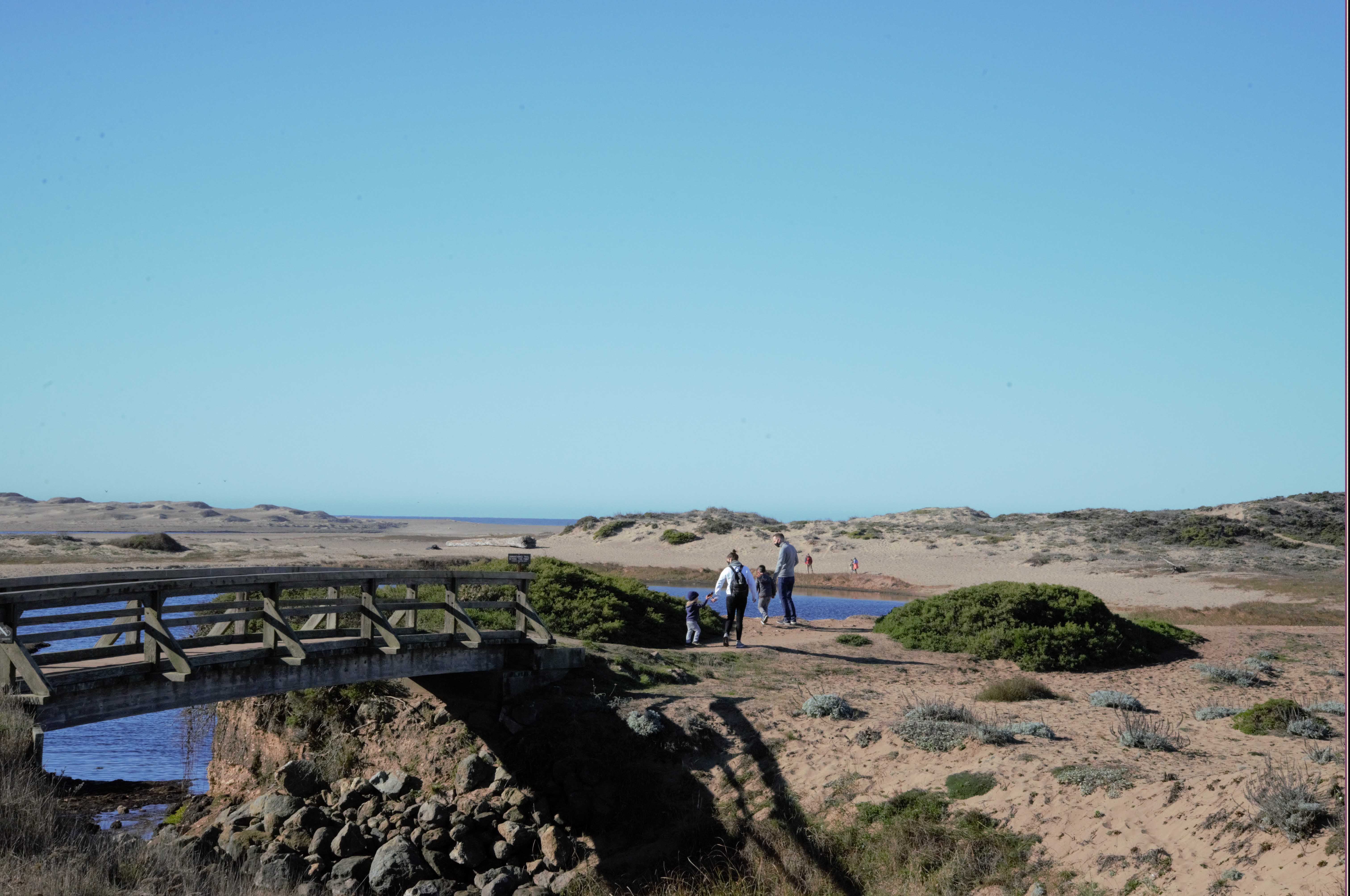
Distance: 1.8 mi. (2.9 km) roundtrip
Abbotts Lagoon is known for fantastic birding opportunities (particularly in the fall and winter), and beautiful wildflowers in the spring. Abbotts Lagoon is actually a series of three coastal lagoons. The upper (easternmost) lagoon is the smallest and contains the freshest water; the lower (westernmost) lagoon is the largest and saltiest.
The beginning of this trail is an easy stroll past pastures and through coastal scrub before skirting along the southern edge of the middle lagoon. After 0.9 miles (1.5 km), you will arrive at a footbridge that crosses a short stream that connects the middle and lower lagoons. From this point, turn around if you are short on time, or feel free to continue for an extra 0.5 miles (800 meters) along the north edge of the lower lagoon and amid the sand dunes to arrive at the Point Reyes Beach (aka the Great Beach). Visit our Hike the Abbotts Lagoon Trail to the Ocean page for more information. Return via the same trail.
This route description alone is not a substitute for a trail map. Print out the park's North District trail map (3,409 KB PDF) before your visit, or pick one up at a visitor center on your way.
Always check current conditions before heading out into the park and familiarize yourself with park regulations . Please practice Leave No Trace principles.
Visit the park's Hiking at Point Reyes National Seashore page for hiking tips and information about trail etiquette and safety.
Visit the park's Trail Advisories and Closures page for current information about closed trails, trails blocked by trees, or other temporary hazards or advisories.
Pets Pets are prohibited on the Abbotts Lagoon Trail. Visit the park's Pets page to learn where pets are welcome at Point Reyes National Seashore.
Accessibility A gentle, soil-cemented trail leads 0.25 miles (400 meters) to an overlook of the lagoon. Beyond this point the trail is packed dirt, typically two or three feet in width. Rain and heavy foot traffic have created ruts in some places. After the footbridge the trail turns to sand, and is likely impassable without a beach-specific wheelchair. Restrooms at the trailhead are accessible and there are two designated parking spaces.
Hike the Abbotts Lagoon Trail to the Ocean the Park Service's write-up
60-90 Minutes · no dogs · season <h2>Winter</h2> <p>The heaviest rainfall occurs in the winter months. Come prepared for rain and drizzle to possibly last for several days. In between winter rains, it is often sunny, calm, and cool.</p> <h2>Spring</h2> <p>Most spring days are windy and the Abbotts Lagoon area frequently experiences strong breezes. Expect cool temperatures in March. By late May and early June, temperatures can be quite pleasant, even warm.</p> <h2>Summer</h2> <p>Although there is very little rain during summer months, there is often dense fog throughout the day in July, August and September with temperatures often 20 degrees cooler than at Bear Valley.</p> <h2>Fall</h2> <p>The coastal areas of Point Reyes experience some of the clearest days in late September, October and early November. The occasional storm will start rolling through in late October, bringing clouds, wind, and rain. The strongest winds occur in November and December during occasional southerly gales.</p>
Start Abbotts Lagoon Trailhead, Point Reyes National Seashore
Distance: 2.8 mi. (4.5 km) roundtrip
Abbotts Lagoon is known for fantastic birding opportunities (particularly in the fall and winter), and beautiful wildflowers in the spring. Abbotts Lagoon is actually a series of three coastal lagoons. The upper (easternmost) lagoon is the smallest and contains the freshest water; the lower (westernmost) lagoon is the largest and saltiest.
The beginning of this trail is an easy stroll past pastures and through coastal scrub before skirting along the southern edge of the middle lagoon. After 0.9 miles (1.5 km), you will arrive at a footbridge that crosses a short stream that connects the middle and lower lagoons. From this point, continue for an extra 0.5 miles (800 meters) along the north edge of the lower lagoon and amid the sand dunes to arrive at the Point Reyes Beach (aka the Great Beach). Return via the same trail.
Be advised that beyond the footbridge, the trail enters the Phillip Burton Wilderness and the trail is considered to be unmaintained. Take note of your surroundings before exploring the beach or the lagoon area so you can ensure you'll be able to find the trail again for your return trip. Please be respectful of fragile coastal dune vegetation.
From Memorial Day to Labor Day, hiking south of Abbotts Lagoon on the Great Beach is prohibited on weekends and holidays to protect nesting western snowy plovers .
Sneaker waves and strong coastal surf are just a few of the hazards of which visitors should be aware while visiting Point Reyes beaches. Beaches may be closed at various times of the year to protect park wildlife and visitors alike. Please visit Point Reyes National Seashore's Current Conditions page to learn about any current beach closures.
This route description alone is not a substitute for a trail map. Print out the park's North District trail map (3,409 KB PDF) before your visit, or pick one up at a visitor center on your way.
Always check current conditions before heading out into the park and familiarize yourself with park regulations . Please practice Leave No Trace principles.
Visit the park's Hiking at Point Reyes National Seashore page for hiking tips and information about trail etiquette and safety.
Visit the park's Trail Advisories and Closures page for current information about closed trails, trails blocked by trees, or other temporary hazards or advisories.
Pets Pets are prohibited on the Abbotts Lagoon Trail. Visit the park's Pets page to learn where pets are welcome at Point Reyes National Seashore.
Accessibility A gentle, soil-cemented trail leads 0.25 miles (400 meters) to an overlook of the lagoon. Beyond this point the trail is packed dirt, typically two or three feet in width. Rain and heavy foot traffic have created ruts in some places. After the footbridge the trail turns to sand, and is likely impassable without a beach-specific wheelchair. Restrooms at the trailhead are accessible and there are two designated parking spaces.