
Tusten Mountain Trail
Trailhead Tusten Mountain Trail Trailhead 663 ft Drive there
Hike the Tusten Mountain Trail 3 mi loop · the Park Service's write-up
1-3 Hours · dogs allowed · season <p>The Tusten Mountain Trail is open year-round. Please exercise caution and situational awareness with weather and river conditions while hiking. Be mindful the trail can get very muddy after heavy rain and quite slippery in wet, snowy, and icy conditions.<br /> <br /> Please be especially careful when hiking during hunting season. Wear bright or flourescent orange or pink.<br /> <br /> During all seasons, there is always a risk of ticks. Please check for ticks on yourself and any pets after hiking.</p>
Start Ten Mile River Access
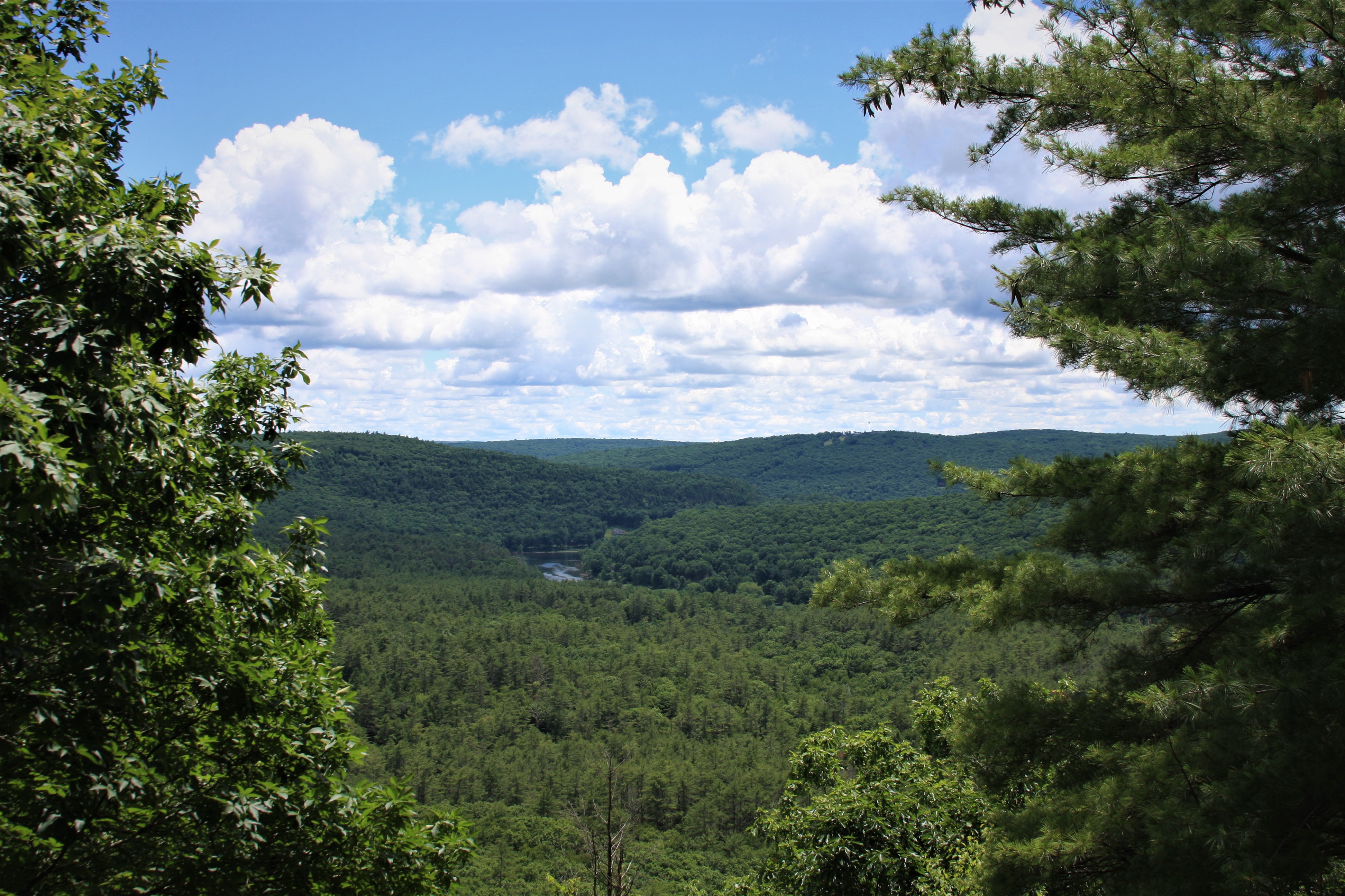
Enjoy this moderately challenging 3-mile (5km) loop trail along the Delaware River and up Tusten Mountain through the remains of historic settlements tucked away in the forest. At the summit of the trail you will be rewarded with a magnificent view of the sparsely populated Upper Delaware River Valley. The trail has an elevation gain of approximately 500 feet (150m) and reaches elevation of over 1120 feet (340m) over sea level.
Starting from the Ten Mile River Access, walk along the Delaware River and glimpse the remains of the early settlements of Reeves Mill (dated 1757-1763) and Tusten (dated 1770s to early 1990s). Although all that remains today are foundations and stone, there was once an active sawmill, gristmill, and tannery in 1830s-1840s among a grove of hemlocks along the river. The stone bridge, constructed in 1875, is also a nod to different days, when Tusten’s industry included lumber and bluestone.
After reaching the trailhead and entering the forest, walk under towering white pines and a mixed eastern deciduous forest of oak, maple, and beech. Keep a lookout for ferns and fungi as red squirrels, grey squirrels, and eastern chipmunks squeak and scurry through the leaves. You may be startled by a deer or bear, serenaded by a melodious wood thrush or vireo, or chilled by screech of red-tailed hawk. Turn your face up and see if you can spot a turkey vulture or a bald eagle soaring overhead. There is also no shortage of unique rock and geologic formations, with the most prominent being bluestone, a durable blue-gray sandstone quarried along trail. Look for telltale signs of human handwork on some remaining rocks—scalloped edge on flat slabs of bluestone, often left in piles.
Trail Use
Trail markers on the trees indicate the trail path. There are two paths, one marked by yellow dot markers and one by red dot markers. These paths connect to form the trail loop. This trail is not regularly maintained and in some areas it may be difficult to distinguish the path on the forest floor. In such cases, always keep an eye out for the trail markers.
Please note that there are no restrooms available. Bikes and motor vehicles are not permitted on the trail. Fires and camping are also prohibited.
This trail is located on lands owned by the Conservation Fund.
Parking and Locating Trailhead
Parking is available at the Ten Mile River Access. This is an unpaved, medium-sized gravel lot able to accommodate approximately 15 cars, but cars are also able to park along Crawford Road next to the river access.
To reach the trailhead from the Ten Mile River Access, follow the gravel road north of the access. You will reach a stone arched bridge over the stream. Limited parking is available next to the stone bridge. Cross the small stone bridge and continue approximately half a mile (800m). A sign will indicate the trailhead and trail sign-in box is in the forested area on the right.
Please do not drive over the stone bridge to park on Tusten Road next to the trailhead. The designated parking area is at the Ten Mile River Access.
Safety
Please exercise caution and situational awareness with weather and river conditions while hiking. We strongly recommend wearing good hiking shoes or boots. Hikers should also use sunscreen, insect (and tick) repellant, wear a hat, and carry drinking water.
This area is open to hunting during hunting season. For safety, please wear bright or fluorescent orange or pink to increase your visibility while hiking in these lawful hunting areas.
During all seasons, there is always a risk of ticks. Please check for ticks on yourself and any pets after hiking. Always be alert for poison ivy, which can be identified by clusters/groups of three leaves together.
While not common, snakes have been seen in the area, including the only venomous snake in the area, the timber rattlesnake. Please exercise situational awareness and do not feed or disturb wildlife.
Please note that there is very limited cell connectivity in the area and cell phones may not receive signal along the river or on the hike.
Pack It In, Pack It Out
Please practice "Leave No Trace" principles and do not litter or leave any waste, including animal waste, behind. Take waste with you and dispose of it properly. There are no trash receptacles available on the trails or at the trailheads, so you must take any trash with you when you leave.
Accessibility This is a moderately difficult trail with many inclines and steep areas. It is uneven and not a paved trail, starting off as a wide, approximately 10 feet (3m) gravel road from the Ten Mile River Access to the Trailhead, and then switching over to a narrower dirt trail, on average 3-4 feet (1-1.5 m) wide. The trail can get wet and muddy in certain areas, but is also rocky as one progresses up the mountain. Close to the beginning of the trail (going counterclockwise), one will cross a series of simple bridges made of long wood planks placed across ditches, gaps, and/or small gorges. These bridges do not have railings or walls so please walk over them carefully. Other obstacles hikers may encounter include tree roots, downed trees, and drop offs. When snow and ice are present, parts of trail can be slippery. Elevation gain is approximately 500 vertical feet (150m). The trail reaches elevation of over 1120 feet (340m) over sea level.