National Historic Site · North Dakota

Trails in Knife River Indian Villages National Historic Site

5 named trails · 8 miles · 3 trailheads · 3 with the Park Service's own write-up. The lines, trailheads and points are the Park Service's; the write-ups are the Service's own words; the climbing is read from USGS elevation along each line.

Open on the parks mapEvery park with trailsPark on nps.gov

5 trails, A to Z.

Hidatsa Trail

0.1 mi one way · 1,686 ft–1,691 ft

Exhibits

1,691 ft 1,686 ft · 0.1 mi high 1,691 ft

Along the way Hidatsa Village Signs Of Life

Walk the Village Trail the Park Service's write-up

15-90 Minutes · dogs allowed

Start Knife River Indian Villages National Historic Site
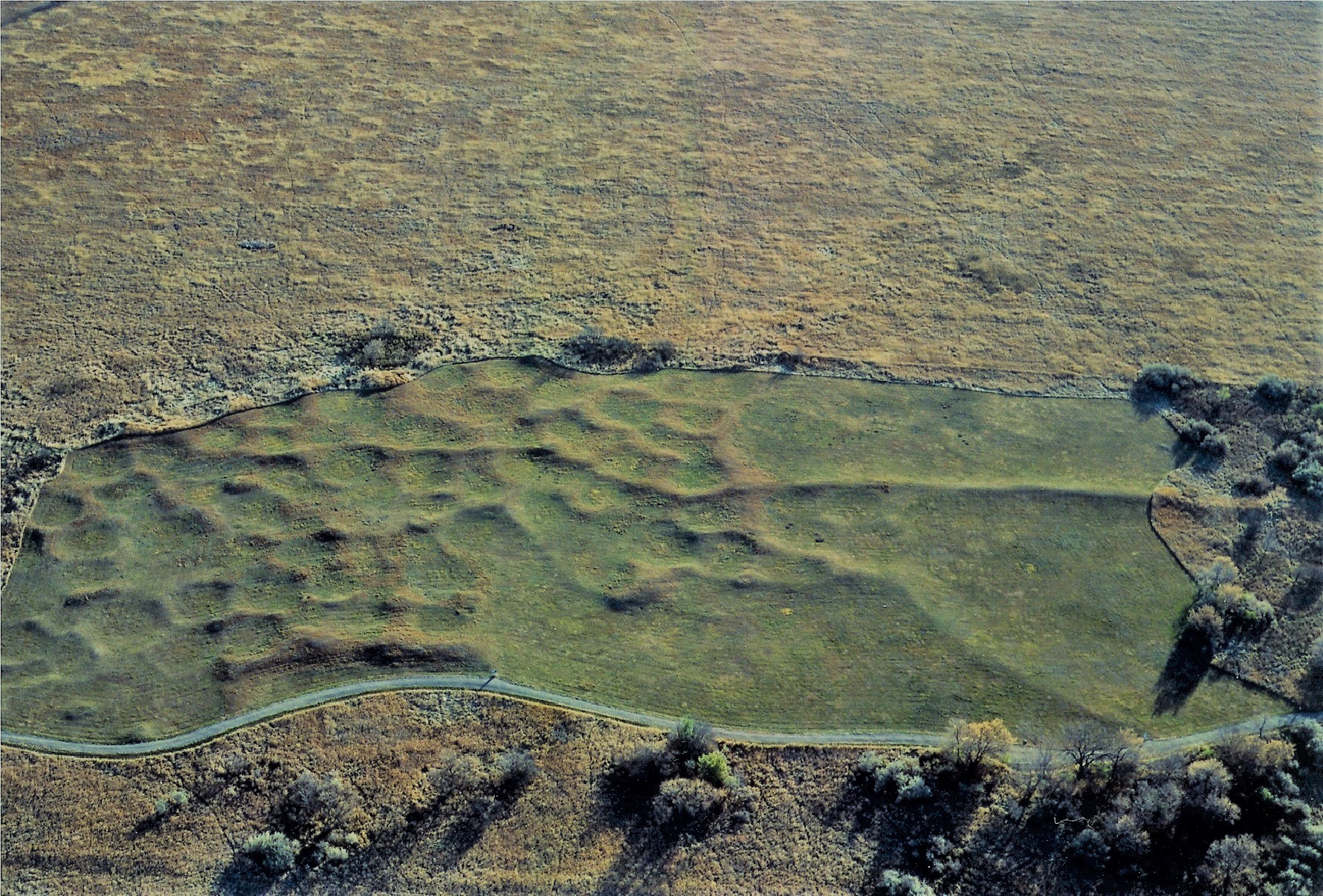
Arial view of earth lodge depressions at a Hidatsa village site.
Arial view of the Lower Hidatsa Site. Photo: KNRI Staff

Walk down the Village Trail and see the remains of the Awatixa Xi'e Village (Lower Hidatsa Site) and Awatixa Village (Sakakawea Site). Starting at the Visitor Center, this flat, gravel trail is 1.3mi/2.1km long passing two village sites, restored prairie grassland, and has a loop at the second village site that includes a walk along the Knife River. Interpretive signs along the trail explain the history of the sites.

At these sites, circular depressions were left in the ground by the earth lodge homes that the Hidatsa lived in. Lower Hidatsa Site was occupied from about 1525 to the 1780s when the first smallpox epidemic forced them to leave their village.

Sakakawea Site is where Sakakawea was living when Lewis and Clark arrived in 1804 and stayed the winter. Sakakawea (Sacagawea/Sacajawea) gave birth to her son Jean Baptiste (Pomp) that winter and then left with Lewis and Clark on their journey. This site was occupied from 1790s until 1837 when smallpox returned a second time.

Accessibility The Village Trail is flat and made of gravel between the villages. The section of trail beside the river is mowed grass. Stairs lead down to the section of trail beside the river. There is a fishing hole with a small dirt parking lot at the end of the trail. The Village Trail is 1.3 miles round trip. To see just the Lower Hidatsa Site is a .5 mile round trip hike. Service animals are allowed.

This hike on nps.gov

North Forest Trail

2.8 mi one way · about 30 ft of climbing · 1,676 ft–1,701 ft

Exhibits

1,676 ft 1,693 ft · 2.0 mi high 1,695 ft

Along the way Signs Of Life

Trailhead Nature Trail 1,676 ft Drive there

Sakakawea Trail

0.2 mi one way · 1,670 ft–1,675 ft

Exhibits

1,675 ft 1,674 ft · 0.2 mi high 1,675 ft

Along the way Fish Of Knife River Floodplain Gardens Lewis & Clark Trail River-Centered

Walk the Village Trail the Park Service's write-up

15-90 Minutes · dogs allowed

Start Knife River Indian Villages National Historic Site

Arial view of earth lodge depressions at a Hidatsa village site.
Arial view of the Lower Hidatsa Site. Photo: KNRI Staff

Walk down the Village Trail and see the remains of the Awatixa Xi'e Village (Lower Hidatsa Site) and Awatixa Village (Sakakawea Site). Starting at the Visitor Center, this flat, gravel trail is 1.3mi/2.1km long passing two village sites, restored prairie grassland, and has a loop at the second village site that includes a walk along the Knife River. Interpretive signs along the trail explain the history of the sites.

At these sites, circular depressions were left in the ground by the earth lodge homes that the Hidatsa lived in. Lower Hidatsa Site was occupied from about 1525 to the 1780s when the first smallpox epidemic forced them to leave their village.

Sakakawea Site is where Sakakawea was living when Lewis and Clark arrived in 1804 and stayed the winter. Sakakawea (Sacagawea/Sacajawea) gave birth to her son Jean Baptiste (Pomp) that winter and then left with Lewis and Clark on their journey. This site was occupied from 1790s until 1837 when smallpox returned a second time.

Accessibility The Village Trail is flat and made of gravel between the villages. The section of trail beside the river is mowed grass. Stairs lead down to the section of trail beside the river. There is a fishing hole with a small dirt parking lot at the end of the trail. The Village Trail is 1.3 miles round trip. To see just the Lower Hidatsa Site is a .5 mile round trip hike. Service animals are allowed.

This hike on nps.gov

Village Trail

0.8 mi one way · 30 ft of descent · 1,670 ft–1,716 ft

Exhibits

1,716 ft 1,687 ft · 0.6 mi high 1,716 ft

Along the way Awatixa Village Awatixa Xie Village Cutbank Archeology Feeding The River Middens River-Centered

Trailhead River Villages Trail 1,716 ft Drive there

Walk the Village Trail the Park Service's write-up

15-90 Minutes · dogs allowed

Start Knife River Indian Villages National Historic Site

Arial view of earth lodge depressions at a Hidatsa village site.
Arial view of the Lower Hidatsa Site. Photo: KNRI Staff

Walk down the Village Trail and see the remains of the Awatixa Xi'e Village (Lower Hidatsa Site) and Awatixa Village (Sakakawea Site). Starting at the Visitor Center, this flat, gravel trail is 1.3mi/2.1km long passing two village sites, restored prairie grassland, and has a loop at the second village site that includes a walk along the Knife River. Interpretive signs along the trail explain the history of the sites.

At these sites, circular depressions were left in the ground by the earth lodge homes that the Hidatsa lived in. Lower Hidatsa Site was occupied from about 1525 to the 1780s when the first smallpox epidemic forced them to leave their village.

Sakakawea Site is where Sakakawea was living when Lewis and Clark arrived in 1804 and stayed the winter. Sakakawea (Sacagawea/Sacajawea) gave birth to her son Jean Baptiste (Pomp) that winter and then left with Lewis and Clark on their journey. This site was occupied from 1790s until 1837 when smallpox returned a second time.

Accessibility The Village Trail is flat and made of gravel between the villages. The section of trail beside the river is mowed grass. Stairs lead down to the section of trail beside the river. There is a fishing hole with a small dirt parking lot at the end of the trail. The Village Trail is 1.3 miles round trip. To see just the Lower Hidatsa Site is a .5 mile round trip hike. Service animals are allowed.

This hike on nps.gov

1 more mapped segment without a name is on the map, not in the list.

About these trails

The lines are the National Park Service's public trails layer, the trailheads and the waterfalls, views, peaks and historic places along them the Service's public points of interest, read 2026-10-14 and simplified for the map. The write-ups are the Service's own "things to do", unedited. Heights come from USGS 3DEP through Terrain Tiles on AWS (Mapzen/Tilezen), read along each line and rounded; a short trail on steep ground can be off by a few tens of feet. Closures change: check the park's own site before you go.