
International Appalachian Trail
Backcountry camps
Along the way Grand Pitch Lean-to Katahdin Brook Lean-to Lunksoos Lean-to Pond Pitch Campsite Wassataquoik campsite Wassataquoik Lean-to
Trailheads Barnard Mountain Trailhead 1,058 ft Drive there · Haskell Gate TrailHead 672 ft Drive there
Hike the International Appalachian Trail the Park Service's write-up
2-3 Days · dogs allowed · Spring, Summer, Fall
Start Barnard Mountain Trailhead
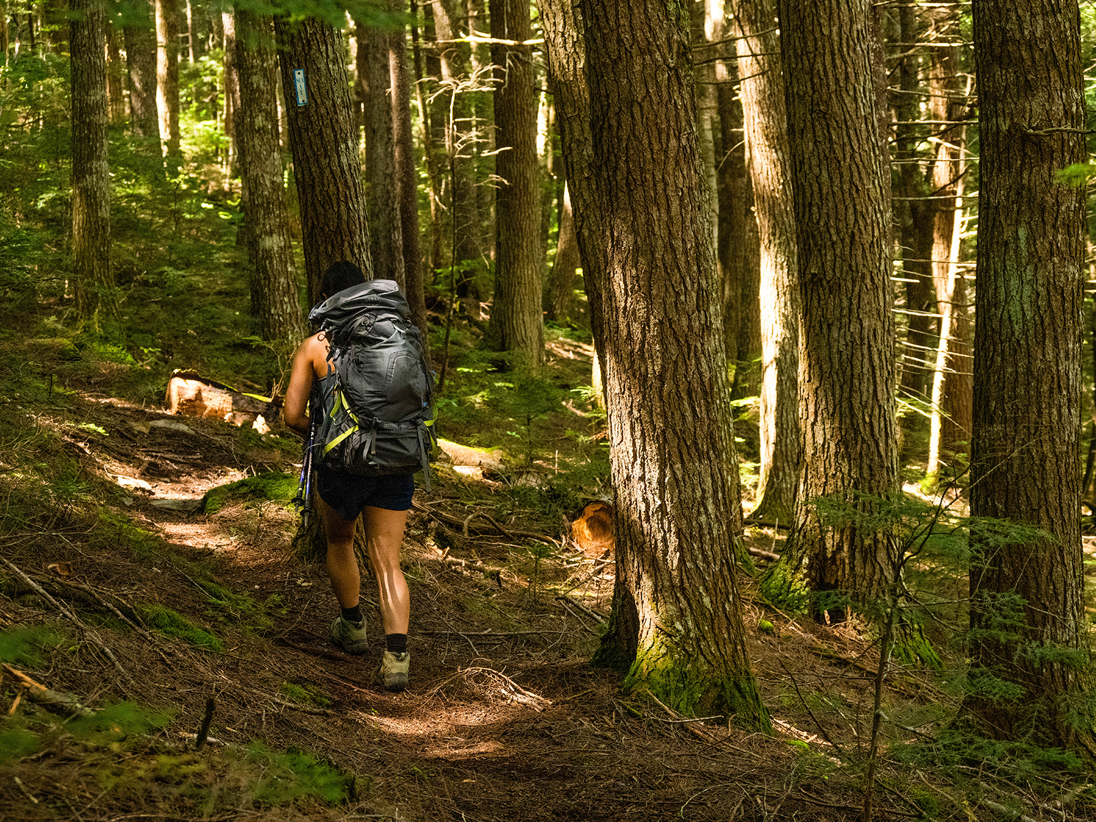
The International Appalachian Trail (IAT) covers approximately 28.9 miles of trail within Katahdin Woods and Waters. The IAT follows old logging roads, crosses Wassataquoik Stream, and meanders through dense boreal forest. The IAT is overgrown in various sections with tall grasses, shrubs, and trees. It is recommended to carry a waterproof map with you, especially if you plan to through hike the entire length of the trail. Signage may be difficult to find in some areas and cell reception is very unreliable. There is no potable water-you will need to pack enough water or purify your own water before drinking . Late spring and summer months typically have high concentrations of biting and stinging insects.
Trail Details
The IAT starts at either the North Gate or at Barnard Mountain Trailhead, located in the southern section. Choose your own adventure by starting at either end; hike a little, or hike the whole thing, it is up to you. The following trail details start at the Barnard Mountain Trailhead parking area. Reverse the steps if you are starting from the north section of the monument.
Park at Barnard Mountain Trailhead, a small dirt and gravel parking area located on the Katahdin Loop Road (GPS coordinate: 45.91512, -68.76034). There is a vault toilet at the trailhead.
Hike north on the IAT following an old logging road for approximately 1 mile and veer right to continue on the IAT. Although the road appears to continue north, follow the sign and veer right to stay on the IAT.
From that point, continue to hike north/north-east for approximately 2.5 miles until you reach an intersection. Turn right and hike approximately 1 mile east to access the Wassataquoik Ford.
The Wassataquoik Ford is a river crossing. Safely cross the Wassataquoik Stream to continue on the IAT, or this can also be a good time to turn around. Review the information on stream crossings before visiting.
After crossing, look for the small rectangular white and blue IAT sign to continue north. From the Wassataquoik Ford, you will travel approximately 24.5 more miles before reaching the North Gate. As you hike, continue to look for the small rectangular white and blue IAT signs (usually found attached to trees). Areas may become very dense with vegetation in this section of the trail with rocky, slippery, muddy, and uneven surfaces. Enjoy the scenic vistas on top of Deasey Mountain and Lunksoos Mountain as you hike towards the North Gate.
Lunksoos Lean-to is approximately 0.5 miles from Lunksoos Mountain. This is a recommended camping spot when through hiking the IAT. Reserve online and enjoy the beauty of the night sky in an International Dark Sky Sanctuary.
From Lunksoos Lean-to it is important to pay close attention to the trail and map due to areas with old logging roads and dense brush. Continue to follow the small rectangular white and blue signs to make sure you are on the IAT.
Once you get to the intersection of the IAT and Telos Tote Trail, turn left to stay on the IAT. Hike north along the East Branch of the Penobscot River to the North Gate. There are some smaller stream crossings ahead and areas of deep mud. You will reach a suspension bridge, after approximately 3.4 miles from the IAT/Telos Tote Trail intersection. Continue north to stay on the IAT. (Note: private property across the bridge.)
From this point on, continue to hike north on the IAT. You will pass Haskell Gate and continue onto New River Road. Proceed with caution, since New River Road is a gravel road shared with motor vehicles. The monument segment of the IAT ends at the North Gate parking area where you can find a vault toilet. If you plan to continue past the monument to follow the IAT/SIA outside of Katahdin Woods and Waters, please contact the Maine Chapter of the IAT .
* There is no access to Baxter State Park from Katahdin Woods and Waters National Monument. Contact Baxter State Park (207-723-5150) for any questions about access to Baxter State Park.
Camping
Camping is only allowed in designated campsites. Walk-ups are welcomed, but reservations through recreation.gov are encouraged. Most sites have a pit toilet available. The following are recommended sites along the IAT:
Katahdin Brook Lean-to
Wassataquoik Lean-to or Wassataquoik Campsite
Lunksoos Lean-to
Grand Pitch Lean-to
Pond Pitch Campsite
Haskell Deadwater Campsite
Stair Falls Campsite
Accessibility This trail is uneven with gravel and rocky surfaces. The IAT crosses the Wassataquoik Stream and some smaller stream crossings . Sections of trail become quite narrow and are very overgrown and dense with vegetation. Be aware of areas of deep mud and exposed roots. New River Road is shared with motor vehicle traffic.
Hike To Barnard Mountain 4 mi round trip · the Park Service's write-up
2-4 Hours · dogs allowed · season <a href="https://www.nps.gov/kaww/planyourvisit/conditions.htm">Check current conditions</a> before visiting.
Start Barnard Mountain Trailhead
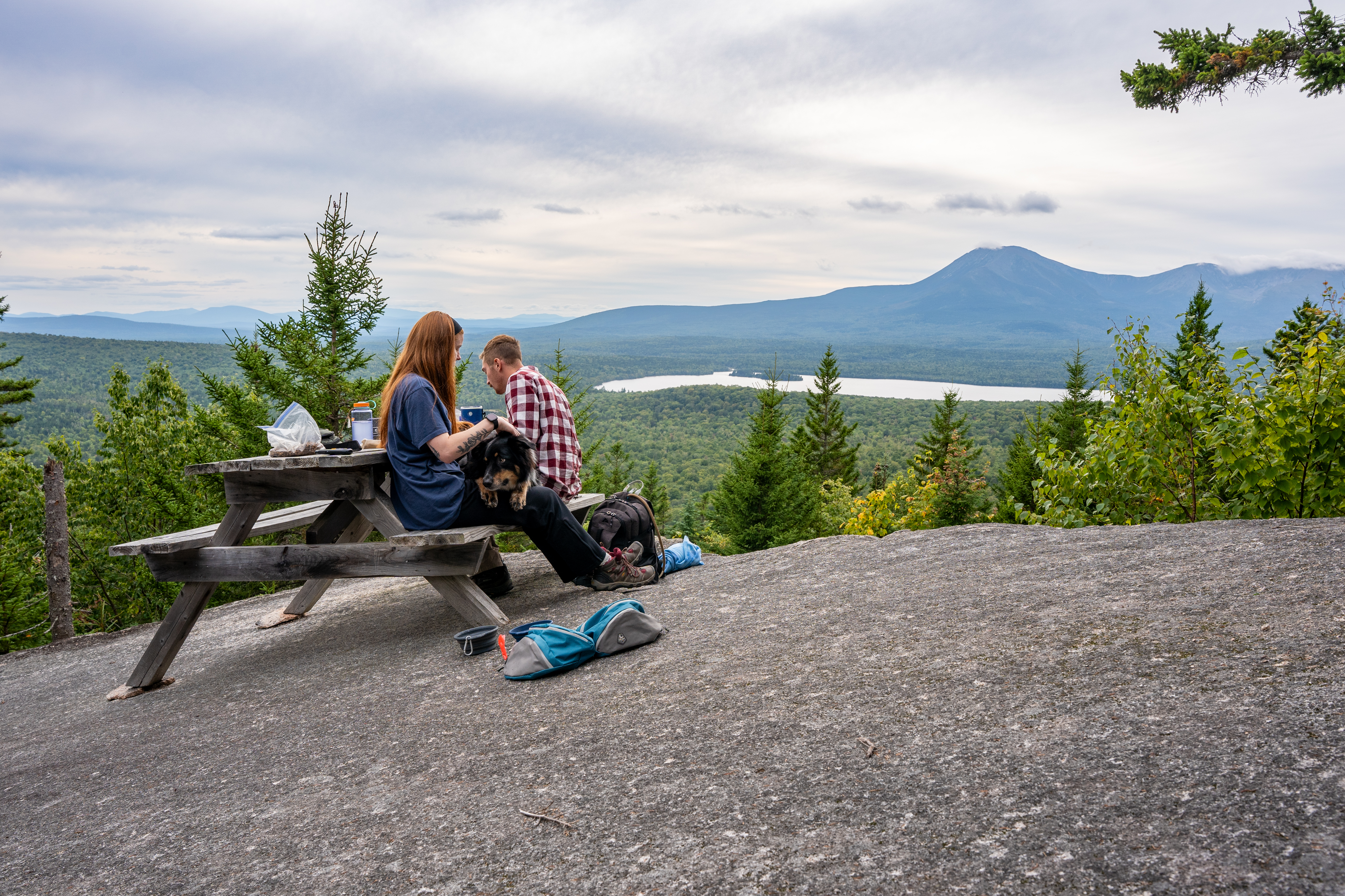
Hike an out and back trail to the top of Barnard Mountain for a magnificent and expansive viewpoint of Katahdin Lake and Mt.Katahdin. To get to the view, you will take a 4 mile round-trip trail that has an elevation gain of 792ft. This is a great location for wildlife viewing. Remember to pack in water to stay hydrated.
Trail Details
Start at the Barnard Mountain Trailhead Parking (located on the loop road). The parking area is a small dirt and gravel area. There is a vault toilet at the trailhead.
After you park your vehicle, hike north on the IAT (an old logging road) for approximately 1 mile and veer right and continue on the IAT for another .5 miles. The Barnard Mountain Trailhead will be on your right.
Take the Barnard Mountain Trail for approximately 0.7 miles to reach the summit and viewpoint. This trail is uneven with exposed roots, rocks, and other organic matter. You will also encounter rock steps.
Leashed pets are allowed on this trail. Carry out all trash and food waste (fruit peels, shells, etc.). Do not feed the wildlife.
Accessibility The trail surface is composed of gravel, dirt, rocks, and organic matter. Parts of the route have a wooden bridge, steep rock steps, and exposed tree roots. There is a vault toilet at the trailhead. No potable water is available.
Hike to Deasey Mountain 10 mi round trip · the Park Service's write-up
5-8 Hours · dogs allowed
Start Wassataquoik Gate Parking Lot
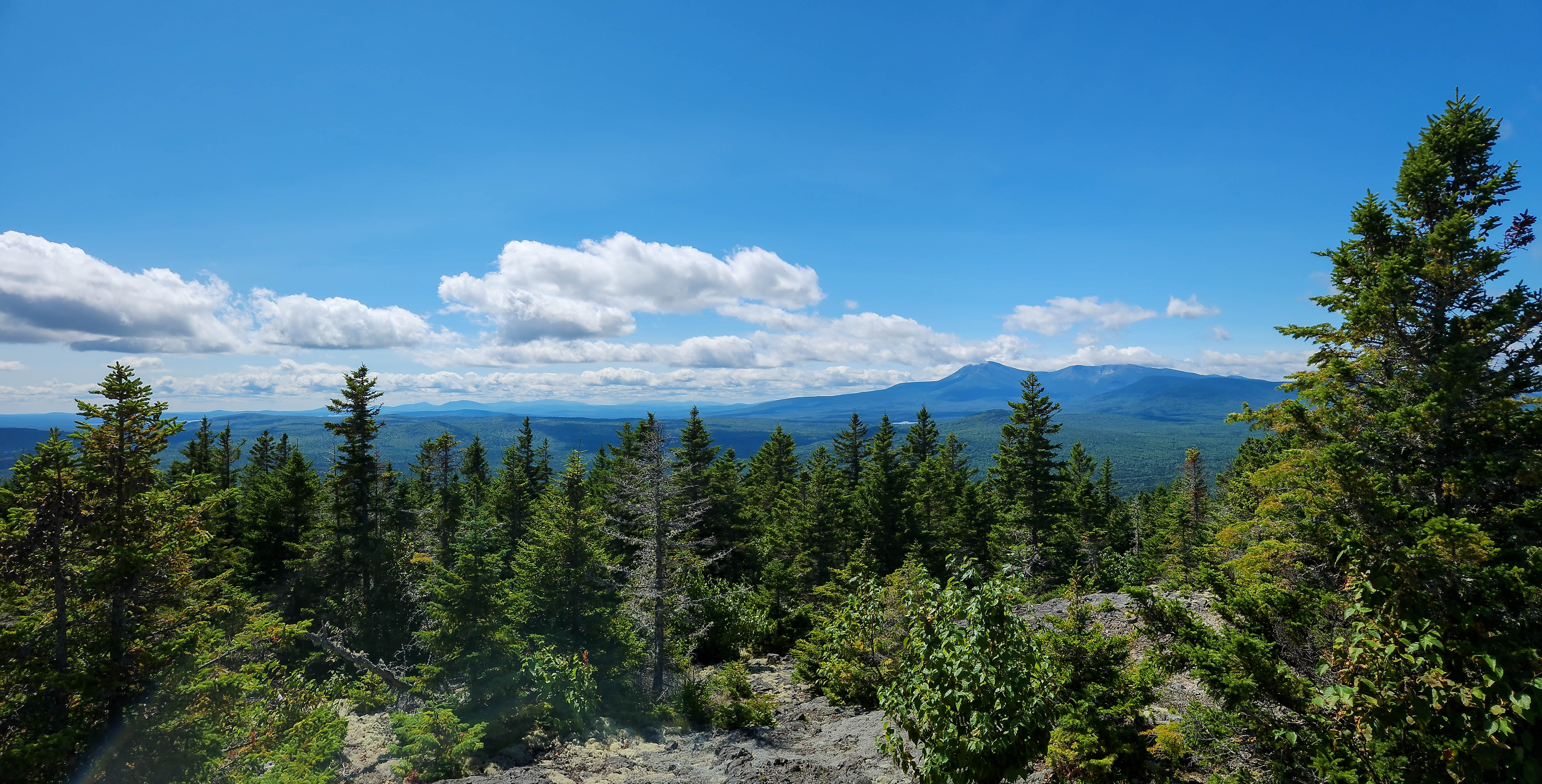
Hike this out and back trail by following the International Appalachian Trail (IAT) up to the top of Deasey Mountain (the tallest peak in the monument) for a 360-degree view of the surrounding landscape. To get to this scenic view, hike 10 mile round-trip with an elevation gain of 1,593ft / 485m. A historic fire lookout building, constructed by the Maine Forest Service in 1929, is located at the summit. Camping is not permitted on top of Deasey Mountain. Pack in your own water or bring a filter system to stay hydrated. There is no potable water.
This hike requires fording a river. Please review the safety information about stream crossings before arriving.
Trail Details
Start at the Wassataquoik Gate Parking Lot. The parking lot is a dirt and gravel area with a vault toilet.
After you park, hike north past the gate for approximately 0.3 miles until you reach a trail (the IAT) to your right and a sign for the Wassataquoik Ford.
Turn right to connect onto the IAT segment that leads you to the bank of Wassataquoik Stream. Hike approximately 890ft to arrive at the stream. Look for the signs marked "Ford" on either side of the bank for designated crossing locations.
Follow safe stream crossing practices when crossing the ford. If you do not feel comfortable, stop here and turn around. A safe hike is a successful hike.
After you cross the Wassataquoik Stream, look for the small IAT signs to follow the IAT for approximately 1.5 miles until you reach a large boulder named Earl's Erratic. Be prepared to cross a large beaver dam and possible flooded areas along the way.
Continue past Earl's Erratic for approximately 1.4 miles to arrive at the IAT and Ed Werler Trail junction. Continue on the IAT by veering left at the junction. Expect muddy, rocky, and slippery surfaces.
After hiking approximately 0.7 miles north from the junction, you will arrive at the site of the old fire warden's cabin. Be aware that this building is not structurally safe and is collapsing.
Hike past the cabin to start the final steep ascent (approximately 0.8 miles) to the top of Deasey Mountain. This portion is very steep and follows a trickling stream. Proceed carefully and check maps frequently to stay on trail.
Once completing the steep trail, follow the signage slightly left to Deasey Mountain Fire Lookout for the summit view. (Continuing right will take you to Lunksoos Mountain.)
Enjoy the views and hydrate before making your way back to the parking lot by retracing your steps the same way you came up.
Accessibility The trail surface to the top of Deasey Mountain is uneven and mostly composed of dirt, rocks, gravel, and organic matter. A large stream crossing is required when you arrive at Wassataquoik Stream Ford. There are areas with deep mud, large boulders, exposed roots, and flooding. Trail may be narrow with brush and vegetation in some areas. There are no toilets after the parking lot.
Hike to Haskell Rock 2 mi one way · the Park Service's write-up
2-4 Hours · dogs allowed · season The North Gate may be closed during the late fall, winter, or early spring months. If you plan to visit during the time that the North Gate is closed, you will start the hike from the parking lot at North Gate. The total distance will be approximately 11 miles (round-trip) from the North Gate parking lot. Check the <a href="https://www.nps.gov/kaww/planyourvisit/conditions.htm">current conditions page</a> before visiting the monument for most updated conditions.
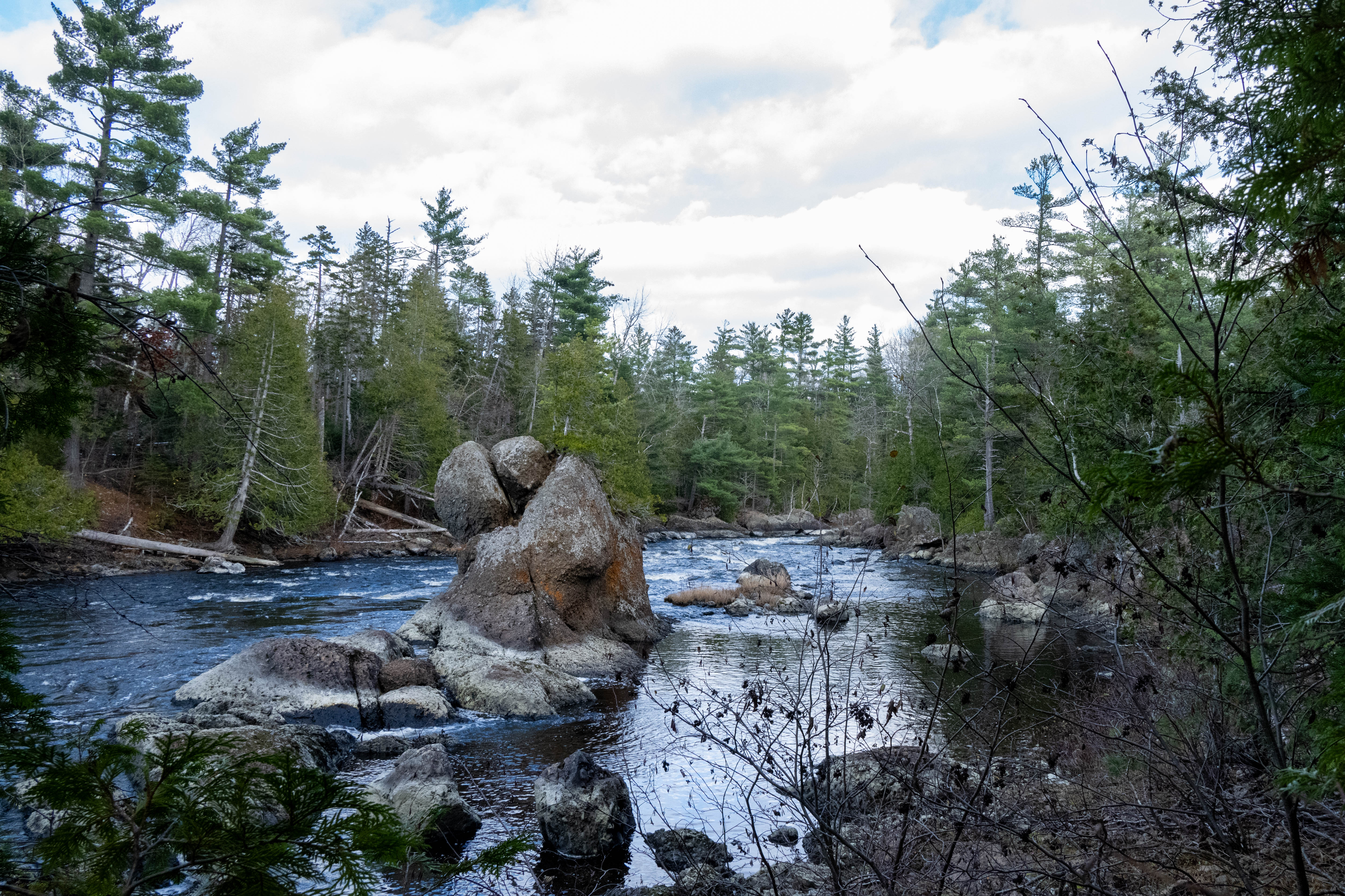
Haskell Rock is a 20ft tall conglomerate bedrock (a clastic sedimentary rock) that protrudes out of the East Branch of the Penobscot River. This rock is approximately 450 million years old. Take a 2 mile (one-way) out and back hike in the northern section of the monument to see this natural feature. There is an elevation gain of 103ft / 31m. Cell reception is very unreliable in this area. There is no potable water, you will need to pack enough water or purify your own water before drinking . Late spring and summer months typically have high concentrations of biting and stinging insects in the area.
Trail Details
Start by entering Katahdin Woods and Waters from the North Entrance and park at Haskell Gate parking area. The parking location is a marked dirt and gravel area on New River Road, just south of the gate. There are no facilities at Haskell Gate parking, so be sure to stop at the North Gate parking lot for the closest vault toilet.
Once parked, safely walk north back to Haskell Gate (it will be to your right). Haskell Gate is one of the International Appalachian Trail (IAT) trailheads within the monument. Take the IAT to Haskell Rock. There are small rectangular white and blue IAT signs along the way to help hikers stay on trail.
Stay on the IAT the entire way (approximately 2.0 miles one-way). Enjoy the sights and sounds in this area at Haskell Rock. It is a great location to observe and imagine past glacial activity in the area .
To return back to Haskell Gate to end your hike. Retrace your steps by following the IAT north.
Reminder: Carry out all trash and food waste (fruit peels, wrappers, nut shells, etc.). Do not feed the wildlife .
Accessibility The trail surface is mostly dirt, gravel, and organic matter. It can be very muddy and slippery. Be careful of larger rocks on the trail and uneven terrain. The Haskell Rock viewing area is uneven and rocky with exposed roots. The elevation gain is 103ft / 31m.