
Reid Lake Trails
Trailhead Reid Lake Foot Travel Area Drive there
Reid Lake Foot Travel Area the Forest Service's write-up
<strong>Reid Lake M-72 Parking</strong> <strong>Recreation Enhancement Act Fee -</strong> <em>Day Use -</em> <ul> <li>Day: $5.00</li> <li>Week: $15.00</li> </ul> <strong>Reid Lake Fowler Road Parking</strong> <ul> <li>No Fee</li> </ul>
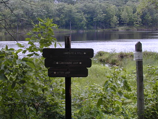
The Reid Lake Area is a little over 3,000 acres in size.
The forest in the area is primarily hardwoods and creates a small, remote, lake environment. The lake is a small, 13-acres, with a variety of fish.
There are 13 miles of gently rolling trail leading you around Reid and Little Trout Lakes, the shoreline of Big Marsh, and offers views of Fannys Marsh and Mossy Bog. You can enjoy a day hike or backpacking with 9 designated first-come first-serve campsites available. Difficulty on the trails ranges from easy to more difficult.
The trails are open for back-country skiing in the winter, and are not groomed.
Flickr Photo Album
Restrictions <strong><em>Allowed - </em></strong>Nonmotorized Use - Hiking, Mechanized Equipment, except Bicycles; Nonmotorized Snow-use - Cross-country Skiing - Trail not groomed, Snowshoeing <strong><em>Prohibited - </em></strong>Motorized Vehicles, Motorized Over-snow Vehicles, Pack and Saddle Animals As a visitor to the National Forest, you are asked to follow certain rules designed to protect the Forest, natural resources and to provide for public safety of visitors. These rules are available to you <a href="http://www.fs.usda.gov/detail/hmnf/notices/?cid=STELPRDB5181640">on-line</a> or at any office of the Huron-Manistee National Forests. Please take time to read and understand them. General Topic orders apply across the Forests. <em><strong>Applicable Orders - </strong></em> <ul><li>Motorized Vehicle Use of Roads, Trails and Off-road Areas</li><li>Occupancy and Use</li></ul>