
Coconino
Begins at the forest's mile 0, 34.8037, -111.7703 - no trailhead mapped Drive to where the trail begins
Kendrick Mountain Wilderness 9.2 mi round trip · the Forest Service's write-up
Kendrick Mountain Wilderness encompasses Kendrick Peak, one of the many peaks of the vast San Francisco mountain volcanic field located on the Coconino Plateau in north-central Arizona. Reaching an elevation of 10,418, the summit affords excellent views of the surrounding plateau, including the San Francisco Peaks to the east, the distant red rock of the Oak Creek/Sycamore Canyon country and Sitgreaves and Bill Williams Mountains to the south, Red Butte and distant views of the north rim of the Grand Canyon to the north. A fire lookout was first established on the summit in the early 1900's, and continues to be staffed to this day. In 2000 a majority of the wilderness was involved in a large wildfire. Dramatic vegetation patterns were created by burn intensities ranging from light to very severe, most evident on the west, north, and east slopes. On-going natural recovery processes may be observed, with early seral species becoming established in the severely burned areas. Characteristic montane coniferous forests, aspen stands, and high mountain meadow grasslands will re-establish with time. Unstable volcanic soils have undergone recurring severe erosion on the steeper slopes within burned areas, causing damage to the trails and access roads. Soils in the burn area will take many more years to re-stabilize.
Three maintained trails totaling 14 miles offer access to the wilderness, and lead hikers to the top of Kendrick Mountain and the fire lookout tower. When the lookout tower is open during summer months, the lookout operator usually welcomes visitors to visit the top of the tower to enjoy the views.
All three trails are managed by the Kaibab National Forest.
Kendrick Mountain Trail : 9.2 miles round-trip. This is a hike to one of the highest vistas in Northern Arizona; from the summit you will be able to see the Grand Canyon and Oak Creek Canyon as well as impressive plants and wildlife.
Pumpkin Trail : 9.6 miles round-trip. This long hike begins in a valley of pine and junipers up through mountain meadows and forests that follows an old road and rises along a steep canyon to the summit of Kendrick Peak.
Bull Basin Trail : 9 miles round-trip. While traveling on switchbacks up to a large meadow you will see the old Kendrick Lookout Cabin built in the early 1900’s.
All of the trails are considered to be challenging due to the lack of water, impressive elevation gains, and the effects of the wildfire, including numerous fallen/falling snags and recurring trail erosion damage which can make route-finding difficult. There are no reliable water sources on the mountain, so pack in plenty of your own!
West Fork of Oak Creek No. 108 the Forest Service's write-up
<ul> <li><strong>Day-use</strong>: $12 per vehicle (up to 5 people)</li> <li><strong>Walk-in, bicycle, bus</strong>: $3 per person</li> <li><strong>Passes:</strong> The <a href="http://www.fs.usda.gov/detail/coconino/home/?cid=stelprdb5416207"><strong>Grand Annual Red Rock Pass</strong></a> is accepted here for entry to the site.</li> </ul> The West Fork of Oak Creek Trailhead and <a href="/recarea/coconino/recarea/?recid=55260&actid=50"><strong>Call of the Canyon Picnic Area</strong></a> are operated by a concessionaire.
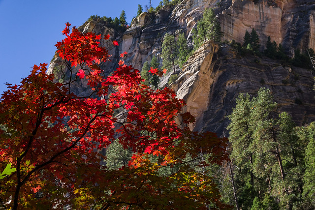
There are a number of reasons why West Fork is one of the most popular trails on the Coconino National Forest. Once you've strolled beside the pleasant little stream that ripples along the canyon floor and looked up, way up, at the dizzying cliffs that tower above it, you will fall in love with it, too. West Fork is fantastic throughout the year. In springtime, migrating songbirds decorate the trees with flashes of brilliance. In autumn, the canyon is ablaze with color, with red and gold leaves floating in clear reflecting pools under a canopy of solid color. In wintertime, icicles decorate from red rock overhangs, and snatches of snow persist in cool shadows. As a matter of fact, you'll probably find a new reason to be here every time you visit.
As for the trail itself, it's an easy stroll, but you do have to cross the stream in a number of places. Usually, that involves negotiating a few strategically placed stepping stones or taking a couple of steps in shallow water. The trail is marked and maintained for the first three miles.
Many hikers explore beyond the end of the maintained trail. Eventually the pathway ends, the route becomes more strenuous, and you will be forced to hike in the stream bed as you continue into the Red Rock-Secret Mountain Wilderness . If you choose to travel the entire 14 mile stretch from one end of the canyon to the other, plan to do a lot of wading and boulder hopping, and even some swimming. Please read this notice describing the strenuous 14 mile long full canyon route between SR 89A to FR 231 (Woody Mountain Road) before attempting this rugged wilderness route.
No matter how long a hike you take here, you'll enjoy it best if you come at a time when the trail is least crowded. Mornings and weekdays are best, better yet if they're in the off-season.
When you do come, remember to take special care and leave this beautiful place better than you found it. Of course you know not to litter, but picking flowers and autumn leaves can cause just as unsightly a scar. So can short-cutting or rock throwing. Treat this natural treasure with the care it deserves and you'll have plenty of reason to come back and see it again and again.
.noprint { display: none; }
Hover mouse over photo to display slideshow controls. View album on Flicker
Restrictions <ul><li>No mechanized vehicles in Wilderness.</li><li>This trail can become extremely crowded, especially on summer weekends.</li><li>It will be closed during times of high fire danger, usually in late June.</li><li>Dogs <strong>must remain leashed</strong> at all times. See <a href="http://www.fs.usda.gov/Internet/FSE_DOCUMENTS/fsbdev3_054750.pdf">Code of Federal Regulations</a> - Title 36 Sec 261.8(D) and Sec.261.16(J)</li></ul>