257 named trails · 209 miles · 2 with the Park Service's own write-up. The lines, trailheads and points are the Park Service's; the write-ups are the Service's own words; the climbing is read from USGS elevation along each line.
257 trails, A to Z.
0.5 mi one way · about 150 ft of climbing · 151 ft–323 ft · native surface · hiking
151 ft
323 ft · 0.5 mi
high 323 ft
On the parks map · Drive to the trail's end
1.5 mi one way · about 50 ft of climbing · 147 ft–173 ft · gravel surface · bike, hiking
154 ft
168 ft · 1.5 mi
high 173 ft
On the parks map · Drive to the trail's end
1.7 mi one way · about 100 ft of climbing · 86 ft–137 ft · native surface · hiking
116 ft
130 ft · 1.6 mi
high 137 ft
On the parks map · Drive to the trail's end
1.4 mi one way · about 40 ft of climbing · 72 ft–116 ft · native surface · hiking
116 ft
109 ft · 1.4 mi
high 116 ft
On the parks map · Drive to the trail's end
1.6 mi one way · about 70 ft of climbing · 66 ft–117 ft · native surface · hiking
114 ft
115 ft · 1.5 mi
high 115 ft
On the parks map · Drive to the trail's end
about 40 ft of climbing · 263 ft–277 ft · wood surface · bike, hiking
On the parks map · Drive to the trail's end
3.6 mi one way · about 100 ft of climbing · 17 ft–130 ft · asphalt surface · bike, hiking
22 ft
43 ft · 2.6 mi
high 45 ft
On the parks map · Drive to the trail's end
about 10 ft of climbing · 210 ft–221 ft · concrete, wood surface · bike, hiking, horse
221 ft
219 ft · 0.0 mi
high 221 ft
On the parks map · Drive to the trail's end
0.1 mi one way · about 20 ft of climbing · 114 ft–138 ft · native, wood surface · hiking
120 ft
138 ft · 0.1 mi
high 138 ft
On the parks map · Drive to the trail's end
10 ft of descent · 616 ft–628 ft · gravel, wood surface · bike, hiking
On the parks map · Drive to the trail's end
0.1 mi one way · 326 ft–327 ft · native surface · hiking
327 ft
326 ft · 0.1 mi
high 327 ft
On the parks map · Drive to the trail's end
325 ft–334 ft · native surface · hiking
On the parks map · Drive to the trail's end
326 ft–327 ft · wood surface · bike, hiking, horse
On the parks map · Drive to the trail's end
375 ft–375 ft · native surface · hiking
On the parks map · Drive to the trail's end
0.1 mi one way · 50 ft of descent · 330 ft–381 ft · native surface · hiking
381 ft
330 ft · 0.1 mi
high 381 ft
On the parks map · Drive to the trail's end
0.3 mi one way · about 50 ft of climbing · 302 ft–362 ft · native surface · hiking
308 ft
358 ft · 0.2 mi
high 362 ft
On the parks map · Drive to the trail's end
440 ft–442 ft · gravel surface · bike, hiking, horse
On the parks map · Drive to the trail's end
1.0 mi one way · 20 ft of descent · 26 ft–177 ft · asphalt surface · bike, hiking
Picnic areas Visitor centers Ranger stations
173 ft
172 ft · 0.3 mi
high 176 ft
Along the way Great Falls Picnic Area Great Falls Ranger Station Great Falls Tavern Visitor Center
On the parks map · Drive to the trail's end
0.9 mi one way · about 30 ft of climbing · 166 ft–196 ft · native surface · hiking
168 ft
178 ft · 0.9 mi
high 196 ft
On the parks map · Drive to the trail's end
0.1 mi one way · 34 ft–40 ft · asphalt surface · bike, hiking
34 ft
40 ft · 0.1 mi
high 40 ft
On the parks map · Drive to the trail's end
352 ft–360 ft · gravel surface · hiking
On the parks map · Drive to the trail's end
2.3 mi one way · about 200 ft of climbing · 238 ft–347 ft · native surface · hiking
336 ft
338 ft · 1.6 mi
high 346 ft
On the parks map · Drive to the trail's end
0.1 mi one way · 409 ft–421 ft · gravel surface · hiking
414 ft
409 ft · 0.1 mi
high 414 ft
On the parks map · Drive to the trail's end
0.3 mi one way · 150 ft of descent · 162 ft–301 ft · native surface · hiking
301 ft
162 ft · 0.3 mi
high 301 ft
On the parks map · Drive to the trail's end
0.5 mi loop · about 100 ft of climbing · 160 ft–276 ft · native surface · hiking
Visitor centers
160 ft
172 ft · 0.5 mi
high 276 ft
Along the way Great Falls Tavern Visitor Center
On the parks map · Drive to the trail's end
187 ft–189 ft · native, wood surface · bike, hiking, horse
History Picnic areas
Along the way Rileys Lockhouse Seneca Creek Picnic Area
On the parks map · Drive to the trail's end
296 ft–300 ft · native surface · hiking
On the parks map · Drive to the trail's end
294 ft–296 ft · wood surface · bike, hiking, horse
On the parks map · Drive to the trail's end
302 ft–305 ft · native, wood surface · bike, hiking
On the parks map · Drive to the trail's end
0.1 mi one way · 352 ft–358 ft · gravel surface · bike, hiking
358 ft
352 ft · 0.1 mi
high 358 ft
On the parks map · Drive to the trail's end
0.1 mi one way · about 40 ft of climbing · 43 ft–111 ft · gravel, native surface · bike, hiking
69 ft
111 ft · 0.0 mi
high 111 ft
On the parks map · Drive to the trail's end
30 ft of descent · 44 ft–69 ft · concrete surface · hiking
69 ft
46 ft · 0.0 mi
high 69 ft
On the parks map · Drive to the trail's end
446 ft–448 ft · gravel surface · hiking
On the parks map · Drive to the trail's end
610 ft–611 ft · gravel surface · bike, hiking, horse
Picnic areas
Along the way Lock 75 Picnic Area
On the parks map · Drive to the trail's end
64 ft–71 ft · native surface · hiking
History Picnic areas
Along the way Lockhouse 8 Lock 8 Picnic Area
On the parks map · Drive to the trail's end
about 20 ft of climbing · 387 ft–402 ft · gravel surface · hiking
387 ft
402 ft · 0.0 mi
high 402 ft
On the parks map · Drive to the trail's end
10 ft of descent · 327 ft–337 ft · gravel surface · hiking
337 ft
327 ft · 0.0 mi
high 337 ft
On the parks map · Drive to the trail's end
10 ft of descent · 401 ft–412 ft · gravel, wood surface · hiking
On the parks map · Drive to the trail's end
0.7 mi one way · about 20 ft of climbing · 100 ft of descent · 456 ft–540 ft · native surface · hiking
516 ft
456 ft · 0.6 mi
high 522 ft
On the parks map · Drive to the trail's end
0.3 mi one way · 10 ft of descent · 124 ft–142 ft · wood surface · hiking
Views
137 ft
126 ft · 0.1 mi
high 137 ft
Along the way Great Falls Overlook
On the parks map · Drive to the trail's end
0.5 mi one way · about 50 ft of climbing · 203 ft–257 ft · native surface · hiking
203 ft
229 ft · 0.4 mi
high 257 ft
On the parks map · Drive to the trail's end
458 ft–462 ft · asphalt surface · hiking
On the parks map · Drive to the trail's end
about 20 ft of climbing · 516 ft–532 ft · gravel surface · hiking
Picnic areas
516 ft
532 ft · 0.0 mi
high 532 ft
Along the way Paw Paw Picnic Area
On the parks map · Drive to the trail's end
1.4 mi one way · about 400 ft of climbing · 536 ft–900 ft · native surface · bike, hiking, horse
Picnic areas
536 ft
538 ft · 1.4 mi
high 900 ft
Along the way Paw Paw Tunnel Picnic Area
Hike Along the Towpath Through the Paw Paw Tunnel the Park Service's write-up
1-2 Minutes · dogs allowed
Start Paw Paw Campground and Picnic Area Parking Lot
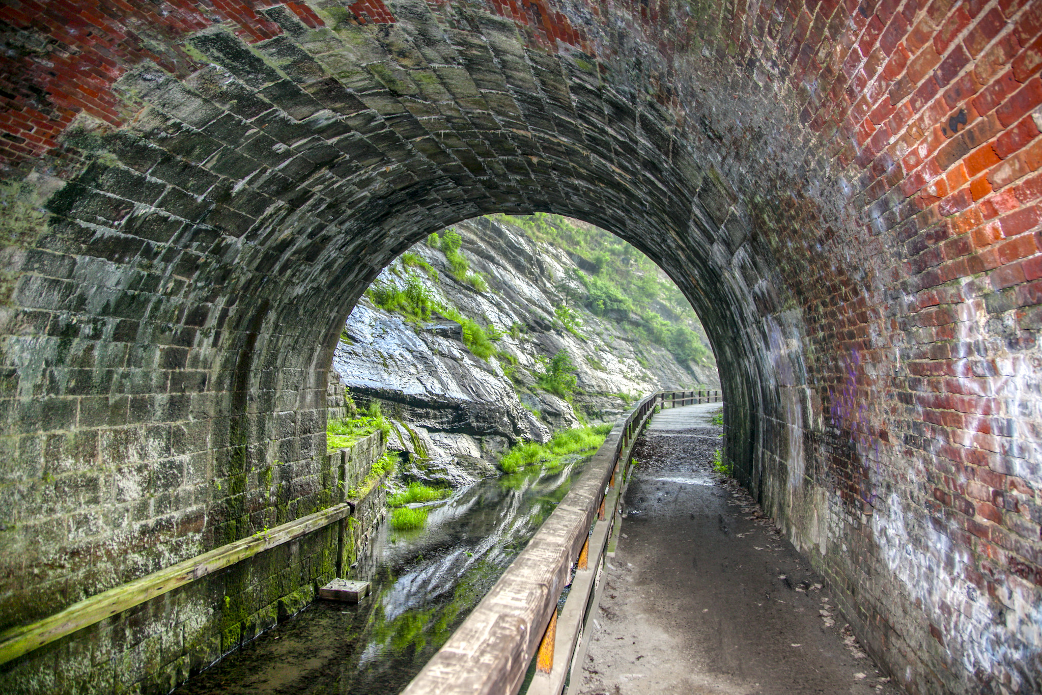
View from inside the Paw Paw Tunnel Photo: NPS | Steve Dean Park at the Paw Paw Tunnel Campground at MP 156 and walk south and through the 3,118-foot Paw Paw Tunnel at MP 155.2. Bring a flashlight to see history of canal operations come to life through the markings of ropes, rub rails, and brass plates throughout the inside of the tunnel.
Address: The Paw Paw Tunnel has no street address, search "Paw Paw Tunnel Campground"
GPS Coordinates: 39°32'39.1"N 78°27'39.2"W
Accessibility This hike follows the C&O Canal towpath, which is a mostly flat path. Towpath access possible at the Paw Paw Campground from a wheelchair via a wide path. The path is semi-steep and the same surface texture as the towpath.
This hike on nps.gov
On the parks map · Drive to the trail's end
0.1 mi one way · 180 ft–183 ft · gravel, native, wood surface · bike, hiking
181 ft
183 ft · 0.1 mi
high 183 ft
On the parks map · Drive to the trail's end
219 ft–227 ft · asphalt, native surface · hiking
On the parks map · Drive to the trail's end
0.1 mi one way · about 10 ft of climbing · 219 ft–234 ft · gravel surface · bike, hiking, horse
234 ft
228 ft · 0.1 mi
high 234 ft
On the parks map · Drive to the trail's end
356 ft–358 ft · wood surface · bike, hiking
356 ft
358 ft · 0.0 mi
high 358 ft
On the parks map · Drive to the trail's end
1.0 mi one way · 154 ft–162 ft · native surface · hiking
Views
162 ft
162 ft · 1.0 mi
high 162 ft
Along the way Observation Deck at Great Fall
On the parks map · Drive to the trail's end
0.2 mi one way · about 40 ft of climbing · 292 ft–327 ft · native surface · hiking
292 ft
327 ft · 0.2 mi
high 327 ft
On the parks map · Drive to the trail's end
about 10 ft of climbing · 21 ft–31 ft · concrete surface · bike, hiking
On the parks map · Drive to the trail's end
115 ft–121 ft · concrete surface · bike, hiking
115 ft
121 ft · 0.0 mi
high 121 ft
On the parks map · Drive to the trail's end
196 ft–198 ft · gravel surface · bike, hiking, horse
On the parks map · Drive to the trail's end
1.0 mi one way · 406 ft–416 ft · gravel surface · bike, hiking, horse
407 ft
415 ft · 1.0 mi
high 416 ft
On the parks map · Drive to the trail's end
1.0 mi one way · 31 ft–37 ft · gravel surface · bike, hiking
33 ft
37 ft · 1.0 mi
high 37 ft
Multi-Park Loop the Park Service's write-up
dogs allowed
Start Thompson Boat House
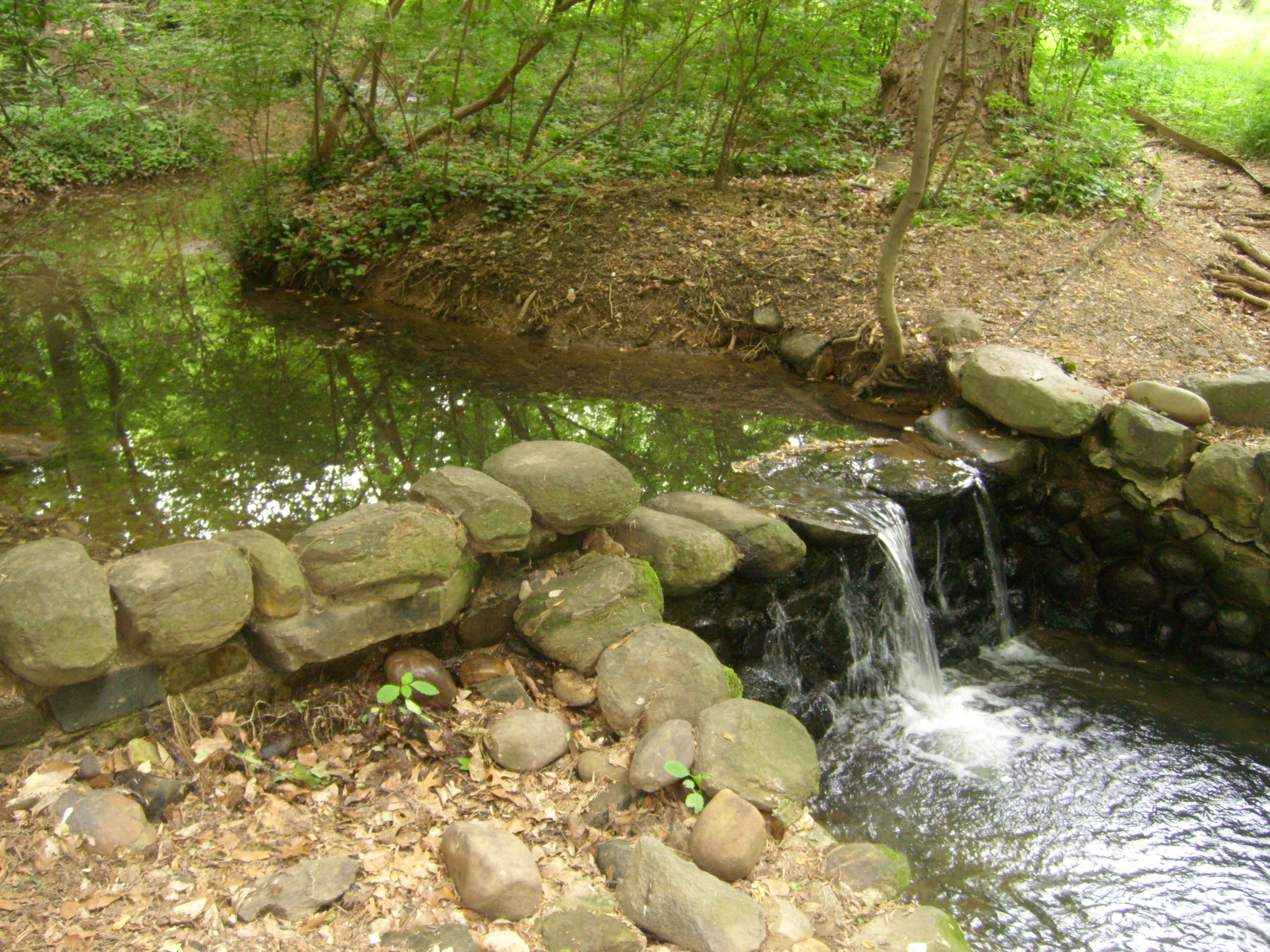
One of the waterfalls in Dumbarton Oaks Park designed by Beatrix Farrand Photo: NPS Photo Overview:
Did you know that Rock Creek Park connects to many other parks in the region? This hike is a 10-mile loop that will take you to some sites managed by Rock Creek Park in Georgetown. In addition, it connects to the Star-Spangled Banner National Historic Trail , Chesapeake and Ohio Canal National Historical Park , George Washington Memorial Parkway , and the National Mall and Memorial Parks .
Directions:
Park your car at Thompson Boat Center . This parking area is metered. Visitors can pay with a card at the box or by using the ParkMobile app.
Walk towards the entrance to Thompson Boat Center parking area, and turn left on the paved path. This is the paved Rock Creek Multi-use Trail.
You will walk through half of the Rock Creek Park exercise course near the Rock Creek and Potomac Parkway. When you cross the bridge at the half-way point, make a sharp left and follow the dirt trail, the Normanstone Trail.
Follow the small park signs towards Montrose Park and Dumbarton Oaks Park . You will walk behind a small tributary that may or may not be dry, depending upon the time of the year. When you reach Lover's Lane, turn right to go to Dumbarton Oaks Park. This park is managed by Rock Creek Park.
Check out Beatrix Farrand's landscaped wild garden. Follow the trail past the falls, and take the trail to the left when it forks.
Follow the fork up to Whitehaven Street NW. Walk towards Wisconsin Avenue NW and carefully cross the road. Pick up the Whitehaven Trail on the other side of Wisconsin Avenue NW.
Take the Whitehaven Trail all the way to Glover-Archbold Park . Just before you reach the Foundry Branch (stream), turn left and take the main trail through Glover-Archbold Park.
For your safety, follow any detours in place.
When you reach M Street NW/Canal Road, turn left and follow the sidewalk a short distance until there's a sharp turn on your left. Follow this trail and go through the tunnel, under Canal Road, and step on to the Chesapeake and Ohio Canal tow path (dirt and stone path).
Follow the towpath to the aqueduct, and continue onto K Street NW/Water Street NW.
Turn left on 34th Street NW, and continue up the hill. Take the path to the footbridge over the canal.
Enter Francis Scott Key Memorial Park . This park is dedicated to the man who wrote the poem that would eventually become our National Anthem. Key lived in a home near this location while he was attorney general for the District of Columbia. His home was heavily altered in the 19th and 20th centuries and was eventually demolished to make way for the Whitehurst Freeway.
Follow the sidewalk to the left, and stay on the sidewalk. Cross Key Bridge.
Take a left at the end of the bridge. Follow signs for the Custis Trail and Theodore Roosevelt Island .
Take a brief detour at Theodore Roosevelt Island if you would like. Enjoy the memorial plaza and take in the natural sounds of this 88.5 acre island. Once known as Analostan Island and Mason's Island, this site was once a camp for African American refugees from slavery and Camp Green, a camp for African American troops partly recruited from freedom seekers. This island was where the first United States Colored Troops trained.
Return to the paved Mount Vernon Trail. Follow the signs to Memorial Bridge.
Cross Memorial Bridge, and walk towards the Lincoln Memorial .
Restrooms are available at the Lincoln Memorial to the left of the stairs.
From the Lincoln Memorial walk up either side of the Reflecting Pool towards the Washington Monument. Stop at the World War II Memorial .
Exit through the Atlantic pillar, and follow the path through Constitution Gardens .
Cross Constitution Avenue NW, and turn left until you reach Virginia Ave. NW.
Turn right on Virginia Avenue NW, and continue until you return to Thompson Boat Center.
This hike allows you to touch on several other trail systems that are accessible from Rock Creek Park. This includes:
184.5 miles of the Chesapeake and Ohio Canal
830 miles of the Potomac Heritage National Scenic Trail
560 miles of the Star-Spangled Banner Trail
27 miles of trail along the George Washington Memorial Parkway (Potomac Heritage Trail and Mount Vernon Trail)
3,000 miles of trails in the Captain John Smith National Historic Trail
680 miles of the Washington-Rochambeau Revolutionary Route National Historic Trail
Accessibility The Normanstone Trail, Whitehaven Trail, and Glover-Archbold Park Trail can be muddy, rugged, and narrow. These trails are not recommended for those who experience difficulty moving over rough terrain. Anyone wanting to attempt this hike can alter it to suit their needs by proceeding through Georgetown and remaining on sidewalks to get to Dumbarton Oaks Park and Montrose Park. Proceeding along city streets will provide visitors with the opportunity to view the architecture of Georgetown homes. The C&O Canal, Mount Vernon Trail and the National Mall are accessible.
This hike on nps.gov
On the parks map · Drive to the trail's end
1.0 mi one way · 353 ft–358 ft · gravel surface · bike, hiking, horse
353 ft
356 ft · 1.0 mi
high 358 ft
On the parks map · Drive to the trail's end
0.8 mi one way · 107 ft–116 ft · gravel surface · bike, hiking
115 ft
114 ft · 0.8 mi
high 116 ft
On the parks map · Drive to the trail's end
1.0 mi one way · 30 ft of descent · 134 ft–164 ft · gravel surface · bike, hiking
Views Picnic areas Visitor centers
163 ft
134 ft · 1.0 mi
high 164 ft
Along the way Great Falls Picnic Area Observation Deck at Great Fall Great Falls Tavern Visitor Center
On the parks map · Drive to the trail's end
0.9 mi one way · 450 ft–459 ft · gravel surface · bike, hiking, horse
455 ft
458 ft · 0.9 mi
high 459 ft
On the parks map · Drive to the trail's end
1.0 mi one way · 34 ft–37 ft · gravel surface · bike, hiking
37 ft
34 ft · 1.0 mi
high 37 ft
On the parks map · Drive to the trail's end
1.0 mi one way · 10 ft of descent · 220 ft–232 ft · gravel surface · bike, hiking, horse
232 ft
227 ft · 1.0 mi
high 232 ft
On the parks map · Drive to the trail's end
0.9 mi one way · 225 ft–237 ft · gravel surface · bike, hiking, horse
225 ft
232 ft · 0.5 mi
high 233 ft
On the parks map · Drive to the trail's end
1.0 mi one way · 230 ft–233 ft · gravel surface · bike, hiking, horse
231 ft
232 ft · 1.0 mi
high 233 ft
On the parks map · Drive to the trail's end
0.9 mi one way · 231 ft–233 ft · gravel surface · bike, hiking, horse
233 ft
232 ft · 0.9 mi
high 233 ft
On the parks map · Drive to the trail's end
1.1 mi one way · 232 ft–237 ft · gravel surface · bike, hiking, horse
Picnic areas
237 ft
233 ft · 1.1 mi
high 237 ft
Along the way Brunswick Picnic Area
On the parks map · Drive to the trail's end
0.9 mi one way · 238 ft–241 ft · gravel surface · bike, hiking, horse
Picnic areas
240 ft
239 ft · 0.9 mi
high 241 ft
Along the way Brunswick Picnic Area
On the parks map · Drive to the trail's end
1.0 mi one way · 239 ft–241 ft · gravel surface · bike, hiking, horse
240 ft
240 ft · 1.0 mi
high 241 ft
On the parks map · Drive to the trail's end
1.0 mi one way · 54 ft–59 ft · gravel surface · bike, hiking
56 ft
54 ft · 1.0 mi
high 59 ft
On the parks map · Drive to the trail's end
1.0 mi one way · 331 ft–336 ft · gravel surface · bike, hiking, horse
332 ft
335 ft · 1.0 mi
high 336 ft
On the parks map · Drive to the trail's end
0.7 mi one way · about 30 ft of climbing · 18 ft–49 ft · gravel surface · bike, hiking
Visitor centers
18 ft
49 ft · 0.6 mi
high 49 ft
Along the way Georgetown Visitor Center
On the parks map · Drive to the trail's end
1.0 mi one way · 112 ft–116 ft · gravel surface · bike, hiking
112 ft
114 ft · 1.0 mi
high 116 ft
On the parks map · Drive to the trail's end
1.0 mi one way · 352 ft–356 ft · gravel surface · bike, hiking, horse
352 ft
355 ft · 1.0 mi
high 356 ft
On the parks map · Drive to the trail's end
1.0 mi one way · 351 ft–357 ft · gravel surface · bike, hiking, horse
356 ft
352 ft · 1.0 mi
high 357 ft
On the parks map · Drive to the trail's end
1.0 mi one way · 343 ft–355 ft · gravel surface · bike, hiking, horse
347 ft
355 ft · 1.0 mi
high 355 ft
On the parks map · Drive to the trail's end
1.0 mi one way · 10 ft of descent · 345 ft–358 ft · gravel surface · bike, hiking, horse
356 ft
349 ft · 1.0 mi
high 358 ft
On the parks map · Drive to the trail's end
1.0 mi one way · 349 ft–355 ft · gravel surface · bike, hiking, horse
355 ft
353 ft · 1.0 mi
high 355 ft
On the parks map · Drive to the trail's end
1.1 mi one way · 20 ft of descent · 355 ft–384 ft · gravel surface · bike, hiking, horse
382 ft
365 ft · 0.5 mi
high 384 ft
On the parks map · Drive to the trail's end
0.7 mi one way · 363 ft–371 ft · gravel surface · bike, hiking, horse
367 ft
366 ft · 0.7 mi
high 371 ft
On the parks map · Drive to the trail's end
1.3 mi one way · 40 ft of descent · 362 ft–406 ft · gravel surface · bike, hiking, horse
History Picnic areas
403 ft
367 ft · 1.3 mi
high 406 ft
Along the way Charles Mill Site Four Locks Picnic Area
On the parks map · Drive to the trail's end
1.0 mi one way · 391 ft–403 ft · gravel surface · bike, hiking, horse
Campgrounds
398 ft
403 ft · 1.0 mi
high 403 ft
Along the way McCoys Ferry Campground
On the parks map · Drive to the trail's end
1.0 mi one way · about 20 ft of climbing · 93 ft–119 ft · gravel surface · bike, hiking
114 ft
112 ft · 1.0 mi
high 119 ft
On the parks map · Drive to the trail's end
1.0 mi one way · 391 ft–401 ft · gravel surface · bike, hiking, horse
Picnic areas
399 ft
399 ft · 1.0 mi
high 401 ft
Along the way McCoys Ferry Picnic Area
On the parks map · Drive to the trail's end
0.9 mi one way · 399 ft–402 ft · gravel surface · bike, hiking, horse
399 ft
399 ft · 0.9 mi
high 402 ft
On the parks map · Drive to the trail's end
1.0 mi one way · 398 ft–401 ft · gravel surface · bike, hiking, horse
398 ft
399 ft · 1.0 mi
high 401 ft
On the parks map · Drive to the trail's end
1.1 mi one way · 398 ft–401 ft · gravel surface · bike, hiking, horse
400 ft
398 ft · 1.1 mi
high 401 ft
On the parks map · Drive to the trail's end
1.0 mi one way · 398 ft–404 ft · gravel surface · bike, hiking, horse
401 ft
400 ft · 1.0 mi
high 404 ft
On the parks map · Drive to the trail's end
1.0 mi one way · 400 ft–401 ft · gravel surface · bike, hiking, horse
401 ft
401 ft · 1.0 mi
high 401 ft
On the parks map · Drive to the trail's end
0.7 mi one way · about 10 ft of climbing · 390 ft–403 ft · gravel surface · bike, hiking, horse
402 ft
401 ft · 0.7 mi
high 403 ft
On the parks map · Drive to the trail's end
1.0 mi one way · 399 ft–402 ft · gravel surface · bike, hiking, horse
401 ft
401 ft · 1.0 mi
high 402 ft
On the parks map · Drive to the trail's end
1.0 mi one way · 393 ft–401 ft · gravel surface · bike, hiking, horse
400 ft
401 ft · 1.0 mi
high 401 ft
On the parks map · Drive to the trail's end
1.0 mi one way · 398 ft–404 ft · gravel surface · bike, hiking, horse
399 ft
401 ft · 0.9 mi
high 404 ft
On the parks map · Drive to the trail's end
1.1 mi one way · 397 ft–402 ft · gravel surface · bike, hiking, horse
402 ft
399 ft · 1.1 mi
high 402 ft
On the parks map · Drive to the trail's end
1.0 mi one way · 401 ft–404 ft · gravel surface · bike, hiking, horse
403 ft
402 ft · 1.0 mi
high 404 ft
On the parks map · Drive to the trail's end
1.0 mi one way · about 20 ft of climbing · 30 ft of descent · 390 ft–414 ft · gravel surface · bike, hiking, horse
412 ft
403 ft · 1.0 mi
high 414 ft
On the parks map · Drive to the trail's end
1.0 mi one way · 412 ft–417 ft · gravel surface · bike, hiking, horse
412 ft
415 ft · 1.0 mi
high 417 ft
On the parks map · Drive to the trail's end
1.0 mi one way · 411 ft–417 ft · gravel surface · bike, hiking, horse
Picnic areas
417 ft
412 ft · 1.0 mi
high 417 ft
Along the way Little Tonoloway Picnic Area
On the parks map · Drive to the trail's end
1.0 mi one way · 416 ft–418 ft · gravel surface · bike, hiking, horse
417 ft
417 ft · 1.0 mi
high 418 ft
On the parks map · Drive to the trail's end
1.0 mi one way · 405 ft–414 ft · gravel surface · bike, hiking, horse
412 ft
408 ft · 1.0 mi
high 414 ft
On the parks map · Drive to the trail's end
1.0 mi one way · 10 ft of descent · 403 ft–417 ft · gravel surface · bike, hiking, horse
417 ft
412 ft · 1.0 mi
high 417 ft
On the parks map · Drive to the trail's end
1.1 mi one way · 114 ft–131 ft · gravel surface · bike, hiking
117 ft
116 ft · 0.4 mi
high 123 ft
On the parks map · Drive to the trail's end
1.0 mi one way · 417 ft–431 ft · gravel surface · bike, hiking, horse
427 ft
419 ft · 1.0 mi
high 431 ft
On the parks map · Drive to the trail's end
1.0 mi one way · 423 ft–428 ft · gravel surface · bike, hiking, horse
426 ft
426 ft · 1.0 mi
high 428 ft
On the parks map · Drive to the trail's end
0.9 mi one way · 421 ft–428 ft · gravel surface · bike, hiking, horse
422 ft
426 ft · 0.9 mi
high 428 ft
On the parks map · Drive to the trail's end
1.0 mi one way · 10 ft of descent · 421 ft–431 ft · gravel surface · bike, hiking, horse
431 ft
422 ft · 1.0 mi
high 431 ft
On the parks map · Drive to the trail's end
1.0 mi one way · 430 ft–442 ft · gravel surface · bike, hiking, horse
437 ft
431 ft · 0.3 mi
high 438 ft
On the parks map · Drive to the trail's end
1.0 mi one way · 439 ft–442 ft · gravel surface · bike, hiking, horse
439 ft
442 ft · 1.0 mi
high 442 ft
On the parks map · Drive to the trail's end
0.9 mi one way · about 20 ft of climbing · 426 ft–451 ft · gravel surface · bike, hiking, horse
447 ft
439 ft · 0.6 mi
high 451 ft
On the parks map · Drive to the trail's end
1.0 mi one way · 443 ft–452 ft · gravel surface · bike, hiking, horse
447 ft
447 ft · 1.0 mi
high 452 ft
On the parks map · Drive to the trail's end
1.0 mi one way · 441 ft–452 ft · gravel surface · bike, hiking, horse
446 ft
448 ft · 1.0 mi
high 452 ft
On the parks map · Drive to the trail's end
1.0 mi one way · 445 ft–457 ft · gravel surface · bike, hiking, horse
449 ft
446 ft · 1.0 mi
high 457 ft
On the parks map · Drive to the trail's end
1.3 mi one way · about 20 ft of climbing · 30 ft of descent · 447 ft–463 ft · gravel surface · bike, hiking, horse
Campgrounds
448 ft
451 ft · 1.2 mi
high 462 ft
Along the way Fifteen Mile Creek Campground
On the parks map · Drive to the trail's end
1.0 mi one way · 452 ft–460 ft · gravel surface · bike, hiking, horse
454 ft
458 ft · 1.0 mi
high 460 ft
On the parks map · Drive to the trail's end
1.0 mi one way · 453 ft–460 ft · gravel surface · bike, hiking, horse
460 ft
454 ft · 1.0 mi
high 460 ft
On the parks map · Drive to the trail's end
1.0 mi one way · 455 ft–463 ft · gravel surface · bike, hiking, horse
458 ft
462 ft · 1.0 mi
high 463 ft
On the parks map · Drive to the trail's end
1.0 mi one way · 10 ft of descent · 452 ft–465 ft · gravel surface · bike, hiking, horse
464 ft
456 ft · 0.9 mi
high 465 ft
On the parks map · Drive to the trail's end
1.0 mi one way · 464 ft–473 ft · gravel surface · bike, hiking, horse
473 ft
464 ft · 1.0 mi
high 473 ft
On the parks map · Drive to the trail's end
0.9 mi one way · 471 ft–473 ft · gravel surface · bike, hiking, horse
473 ft
472 ft · 0.9 mi
high 473 ft
On the parks map · Drive to the trail's end
1.1 mi one way · 468 ft–474 ft · gravel surface · bike, hiking, horse
469 ft
473 ft · 1.1 mi
high 474 ft
On the parks map · Drive to the trail's end
0.9 mi one way · 10 ft of descent · 468 ft–482 ft · gravel surface · bike, hiking, horse
482 ft
469 ft · 0.9 mi
high 482 ft
On the parks map · Drive to the trail's end
1.0 mi one way · 163 ft–167 ft · gravel surface · bike, hiking
163 ft
163 ft · 1.0 mi
high 167 ft
On the parks map · Drive to the trail's end
1.0 mi one way · 480 ft–483 ft · gravel surface · bike, hiking, horse
480 ft
482 ft · 0.9 mi
high 483 ft
On the parks map · Drive to the trail's end
1.0 mi one way · 469 ft–483 ft · gravel surface · bike, hiking, horse
475 ft
480 ft · 1.0 mi
high 483 ft
On the parks map · Drive to the trail's end
1.0 mi one way · 10 ft of descent · 472 ft–484 ft · gravel surface · bike, hiking, horse
484 ft
476 ft · 1.0 mi
high 484 ft
On the parks map · Drive to the trail's end
1.0 mi one way · 482 ft–489 ft · gravel surface · bike, hiking, horse
484 ft
482 ft · 1.0 mi
high 489 ft
On the parks map · Drive to the trail's end
1.0 mi one way · 40 ft of descent · 485 ft–538 ft · gravel surface · bike, hiking, horse
529 ft
485 ft · 0.8 mi
high 529 ft
On the parks map · Drive to the trail's end
1.1 mi one way · about 350 ft of climbing · 529 ft–878 ft · gravel, wood surface · bike, hiking, horse
Picnic areas
567 ft
540 ft · 0.2 mi
high 567 ft
Along the way Paw Paw Tunnel Picnic Area
On the parks map · Drive to the trail's end
1.0 mi one way · 522 ft–533 ft · gravel surface · bike, hiking, horse
Picnic areas
524 ft
530 ft · 1.0 mi
high 533 ft
Along the way Paw Paw Picnic Area
On the parks map · Drive to the trail's end
1.0 mi one way · 520 ft–527 ft · gravel surface · bike, hiking, horse
523 ft
525 ft · 1.0 mi
high 527 ft
On the parks map · Drive to the trail's end
1.0 mi one way · 521 ft–526 ft · gravel surface · bike, hiking, horse
521 ft
523 ft · 1.0 mi
high 526 ft
On the parks map · Drive to the trail's end
1.0 mi one way · 518 ft–531 ft · gravel surface · bike, hiking, horse
527 ft
521 ft · 1.0 mi
high 531 ft
On the parks map · Drive to the trail's end
1.0 mi one way · 10 ft of descent · 160 ft–172 ft · gravel surface · bike, hiking, horse
Picnic areas
171 ft
163 ft · 0.6 mi
high 171 ft
Along the way Swains Lock Concession
On the parks map · Drive to the trail's end
1.0 mi one way · 527 ft–531 ft · gravel surface · bike, hiking, horse
530 ft
528 ft · 1.0 mi
high 531 ft
On the parks map · Drive to the trail's end
1.0 mi one way · 529 ft–537 ft · gravel surface · bike, hiking, horse
536 ft
532 ft · 1.0 mi
high 537 ft
On the parks map · Drive to the trail's end
1.0 mi one way · 531 ft–537 ft · gravel surface · bike, hiking, horse
535 ft
536 ft · 1.0 mi
high 537 ft
On the parks map · Drive to the trail's end
1.0 mi one way · 535 ft–538 ft · gravel surface · bike, hiking, horse
537 ft
536 ft · 1.0 mi
high 538 ft
On the parks map · Drive to the trail's end
1.0 mi one way · 536 ft–542 ft · gravel surface · bike, hiking, horse
542 ft
537 ft · 1.0 mi
high 542 ft
On the parks map · Drive to the trail's end
1.0 mi one way · 536 ft–545 ft · gravel surface · bike, hiking, horse
543 ft
543 ft · 1.0 mi
high 545 ft
On the parks map · Drive to the trail's end
1.0 mi one way · 30 ft of descent · 541 ft–568 ft · gravel surface · bike, hiking, horse
Picnic areas
568 ft
543 ft · 1.0 mi
high 568 ft
Along the way Battie Mixon Picnic Area Oldtown Picnic Area
On the parks map · Drive to the trail's end
1.0 mi one way · about 20 ft of climbing · 568 ft–590 ft · gravel surface · bike, hiking, horse
568 ft
569 ft · 1.0 mi
high 590 ft
On the parks map · Drive to the trail's end
1.0 mi one way · 562 ft–573 ft · gravel surface · bike, hiking, horse
569 ft
566 ft · 1.0 mi
high 573 ft
On the parks map · Drive to the trail's end
1.0 mi one way · 567 ft–569 ft · gravel surface · bike, hiking, horse
569 ft
569 ft · 1.0 mi
high 569 ft
On the parks map · Drive to the trail's end
1.1 mi one way · 168 ft–176 ft · gravel surface · bike, hiking, horse
168 ft
169 ft · 1.1 mi
high 175 ft
On the parks map · Drive to the trail's end
1.0 mi one way · 561 ft–569 ft · gravel surface · bike, hiking, horse
567 ft
569 ft · 1.0 mi
high 569 ft
On the parks map · Drive to the trail's end
1.0 mi one way · 561 ft–570 ft · gravel surface · bike, hiking, horse
562 ft
568 ft · 1.0 mi
high 570 ft
On the parks map · Drive to the trail's end
1.0 mi one way · 560 ft–566 ft · gravel surface · bike, hiking, horse
563 ft
561 ft · 1.0 mi
high 566 ft
On the parks map · Drive to the trail's end
1.0 mi one way · 10 ft of descent · 562 ft–572 ft · gravel surface · bike, hiking, horse
Picnic areas
572 ft
563 ft · 1.0 mi
high 572 ft
Along the way Spring Gap Picnic Area
On the parks map · Drive to the trail's end
1.0 mi one way · 568 ft–583 ft · gravel surface · bike, hiking, horse
574 ft
572 ft · 1.0 mi
high 583 ft
On the parks map · Drive to the trail's end
1.0 mi one way · 40 ft of descent · 574 ft–610 ft · gravel surface · bike, hiking, horse
Picnic areas
609 ft
574 ft · 1.0 mi
high 610 ft
Along the way Lock 75 Picnic Area North Branch Picnic Area
On the parks map · Drive to the trail's end
1.0 mi one way · 605 ft–609 ft · gravel surface · bike, hiking, horse
609 ft
608 ft · 1.0 mi
high 609 ft
On the parks map · Drive to the trail's end
1.0 mi one way · 607 ft–611 ft · gravel surface · bike, hiking, horse
608 ft
609 ft · 1.0 mi
high 611 ft
On the parks map · Drive to the trail's end
1.0 mi one way · 608 ft–614 ft · gravel surface · bike, hiking, horse
611 ft
608 ft · 1.0 mi
high 614 ft
On the parks map · Drive to the trail's end
1.0 mi one way · 602 ft–612 ft · gravel surface · bike, hiking, horse
610 ft
611 ft · 1.0 mi
high 612 ft
On the parks map · Drive to the trail's end
1.0 mi one way · 165 ft–173 ft · gravel surface · bike, hiking, horse
170 ft
167 ft · 1.0 mi
high 173 ft
On the parks map · Drive to the trail's end
1.0 mi one way · 601 ft–613 ft · gravel surface · bike, hiking, horse
605 ft
610 ft · 1.0 mi
high 613 ft
On the parks map · Drive to the trail's end
1.0 mi one way · 10 ft of descent · 597 ft–610 ft · gravel surface · bike, hiking, horse
608 ft
605 ft · 0.8 mi
high 610 ft
On the parks map · Drive to the trail's end
1.0 mi one way · 608 ft–611 ft · gravel surface · bike, hiking, horse
611 ft
609 ft · 1.0 mi
high 611 ft
On the parks map · Drive to the trail's end
1.0 mi one way · 609 ft–617 ft · gravel surface · bike, hiking
616 ft
610 ft · 1.0 mi
high 617 ft
On the parks map · Drive to the trail's end
0.5 mi one way · 10 ft of descent · 617 ft–628 ft · gravel surface · bike, hiking
628 ft
617 ft · 0.5 mi
high 628 ft
On the parks map · Drive to the trail's end
1.0 mi one way · 172 ft–181 ft · gravel surface · bike, hiking, horse
179 ft
173 ft · 1.0 mi
high 181 ft
On the parks map · Drive to the trail's end
0.9 mi one way · 177 ft–180 ft · gravel surface · bike, hiking, horse
178 ft
179 ft · 0.9 mi
high 180 ft
On the parks map · Drive to the trail's end
1.0 mi one way · 175 ft–185 ft · gravel surface · bike, hiking, horse
184 ft
178 ft · 1.0 mi
high 185 ft
On the parks map · Drive to the trail's end
0.9 mi one way · 180 ft–194 ft · gravel, wood surface · bike, hiking, horse
History Picnic areas
187 ft
190 ft · 0.7 mi
high 190 ft
Along the way Rileys Lockhouse Lock 23 Picnic Area Seneca Creek Picnic Area Seneca Creek Picnic Area
On the parks map · Drive to the trail's end
1.0 mi one way · 190 ft–196 ft · gravel surface · bike, hiking, horse
192 ft
190 ft · 1.0 mi
high 196 ft
On the parks map · Drive to the trail's end
1.0 mi one way · 192 ft–194 ft · gravel surface · bike, hiking, horse
193 ft
193 ft · 1.0 mi
high 194 ft
On the parks map · Drive to the trail's end
1.0 mi one way · 192 ft–196 ft · gravel surface · bike, hiking, horse
196 ft
193 ft · 1.0 mi
high 196 ft
On the parks map · Drive to the trail's end
1.0 mi one way · 194 ft–197 ft · gravel surface · bike, hiking, horse
197 ft
196 ft · 1.0 mi
high 197 ft
On the parks map · Drive to the trail's end
1.0 mi one way · 194 ft–199 ft · gravel surface · bike, hiking, horse
198 ft
197 ft · 1.0 mi
high 199 ft
On the parks map · Drive to the trail's end
1.0 mi one way · 194 ft–199 ft · gravel surface · bike, hiking, horse
195 ft
199 ft · 1.0 mi
high 199 ft
On the parks map · Drive to the trail's end
1.0 mi one way · 193 ft–196 ft · gravel surface · bike, hiking, horse
194 ft
194 ft · 1.0 mi
high 196 ft
On the parks map · Drive to the trail's end
1.0 mi one way · 34 ft–37 ft · gravel surface · bike, hiking
34 ft
37 ft · 1.0 mi
high 37 ft
On the parks map · Drive to the trail's end
1.0 mi one way · 10 ft of descent · 193 ft–203 ft · gravel surface · bike, hiking, horse
203 ft
194 ft · 1.0 mi
high 203 ft
On the parks map · Drive to the trail's end
1.0 mi one way · 195 ft–204 ft · gravel, wood surface · bike, hiking, horse
199 ft
203 ft · 0.9 mi
high 204 ft
On the parks map · Drive to the trail's end
1.4 mi one way · 203 ft–206 ft · gravel surface · bike, hiking, horse
204 ft
204 ft · 1.4 mi
high 206 ft
On the parks map · Drive to the trail's end
0.9 mi one way · 201 ft–206 ft · gravel surface · bike, hiking, horse
201 ft
204 ft · 0.9 mi
high 206 ft
On the parks map · Drive to the trail's end
0.9 mi one way · 200 ft–203 ft · gravel surface · bike, hiking, horse
203 ft
201 ft · 0.9 mi
high 203 ft
On the parks map · Drive to the trail's end
0.7 mi one way · 203 ft–204 ft · gravel surface · bike, hiking, horse
204 ft
203 ft · 0.7 mi
high 204 ft
On the parks map · Drive to the trail's end
1.0 mi one way · 202 ft–206 ft · gravel surface · bike, hiking, horse
202 ft
204 ft · 1.0 mi
high 206 ft
On the parks map · Drive to the trail's end
0.9 mi one way · about 10 ft of climbing · 194 ft–207 ft · gravel surface · bike, hiking, horse
195 ft
202 ft · 0.9 mi
high 207 ft
On the parks map · Drive to the trail's end
1.3 mi one way · about 20 ft of climbing · 30 ft of descent · 193 ft–209 ft · gravel surface · bike, hiking, horse
208 ft
196 ft · 1.3 mi
high 209 ft
On the parks map · Drive to the trail's end
1.0 mi one way · 206 ft–211 ft · gravel surface · bike, hiking, horse
Picnic areas
211 ft
208 ft · 1.0 mi
high 211 ft
Along the way Warm Water Fishing Picnic Area
On the parks map · Drive to the trail's end
1.0 mi one way · 34 ft–39 ft · gravel surface · bike, hiking
38 ft
34 ft · 1.0 mi
high 39 ft
On the parks map · Drive to the trail's end
0.8 mi one way · 211 ft–215 ft · gravel surface · bike, hiking, horse
211 ft
212 ft · 0.8 mi
high 215 ft
On the parks map · Drive to the trail's end
1.0 mi one way · 10 ft of descent · 204 ft–219 ft · gravel surface · bike, hiking, horse
216 ft
210 ft · 0.6 mi
high 216 ft
On the parks map · Drive to the trail's end
1.1 mi one way · about 10 ft of climbing · 193 ft–220 ft · gravel surface · bike, hiking, horse
Picnic areas
219 ft
216 ft · 0.8 mi
high 220 ft
Along the way Monocacy Aqueduct Picnic Area
On the parks map · Drive to the trail's end
1.0 mi one way · 218 ft–221 ft · gravel surface · bike, hiking, horse
218 ft
219 ft · 1.0 mi
high 221 ft
On the parks map · Drive to the trail's end
1.0 mi one way · 218 ft–223 ft · gravel surface · bike, hiking, horse
Picnic areas
221 ft
218 ft · 1.0 mi
high 223 ft
Along the way Nolands Ferry Picnic Area
On the parks map · Drive to the trail's end
1.0 mi one way · 219 ft–223 ft · gravel surface · bike, hiking, horse
223 ft
220 ft · 1.0 mi
high 223 ft
On the parks map · Drive to the trail's end
1.0 mi one way · 218 ft–223 ft · gravel surface · bike, hiking, horse
218 ft
223 ft · 1.0 mi
high 223 ft
On the parks map · Drive to the trail's end
1.0 mi one way · 216 ft–220 ft · gravel surface · bike, hiking, horse
220 ft
218 ft · 1.0 mi
high 220 ft
On the parks map · Drive to the trail's end
1.1 mi one way · about 10 ft of climbing · 210 ft–226 ft · gravel surface · bike, hiking, horse
226 ft
219 ft · 1.1 mi
high 226 ft
On the parks map · Drive to the trail's end
0.9 mi one way · 225 ft–229 ft · gravel surface · bike, hiking, horse
228 ft
226 ft · 0.9 mi
high 229 ft
On the parks map · Drive to the trail's end
1.0 mi one way · 38 ft–53 ft · gravel surface · bike, hiking
50 ft
43 ft · 1.0 mi
high 53 ft
On the parks map · Drive to the trail's end
1.0 mi one way · 238 ft–241 ft · gravel surface · bike, hiking, horse
241 ft
239 ft · 1.1 mi
high 241 ft
On the parks map · Drive to the trail's end
1.0 mi one way · 244 ft–250 ft · gravel surface · bike, hiking, horse
246 ft
249 ft · 0.9 mi
high 250 ft
On the parks map · Drive to the trail's end
1.0 mi one way · 247 ft–256 ft · gravel surface · bike, hiking, horse
249 ft
247 ft · 1.0 mi
high 256 ft
On the parks map · Drive to the trail's end
1.0 mi one way · 48 ft–53 ft · gravel surface · bike, hiking
52 ft
51 ft · 1.0 mi
high 53 ft
On the parks map · Drive to the trail's end
1.0 mi one way · 20 ft of descent · 249 ft–266 ft · gravel surface · bike, hiking, horse
264 ft
250 ft · 0.7 mi
high 264 ft
On the parks map · Drive to the trail's end
0.9 mi one way · 262 ft–273 ft · gravel surface · bike, hiking, horse
267 ft
265 ft · 0.9 mi
high 273 ft
On the parks map · Drive to the trail's end
1.1 mi one way · 20 ft of descent · 268 ft–287 ft · gravel surface · bike, hiking, horse
287 ft
268 ft · 1.1 mi
high 287 ft
On the parks map · Drive to the trail's end
0.9 mi one way · 279 ft–290 ft · gravel surface · bike, hiking, horse
287 ft
286 ft · 0.9 mi
high 290 ft
On the parks map · Drive to the trail's end
1.0 mi one way · 284 ft–291 ft · gravel surface · bike, hiking, horse
Picnic areas
285 ft
287 ft · 1.0 mi
high 291 ft
Along the way Dargan Bend Picnic Area
On the parks map · Drive to the trail's end
1.0 mi one way · 283 ft–290 ft · gravel surface · bike, hiking, horse
285 ft
285 ft · 1.0 mi
high 290 ft
On the parks map · Drive to the trail's end
1.1 mi one way · 10 ft of descent · 281 ft–294 ft · gravel surface · bike, hiking, horse
294 ft
285 ft · 1.1 mi
high 294 ft
On the parks map · Drive to the trail's end
1.0 mi one way · 289 ft–297 ft · gravel surface · bike, hiking, horse
290 ft
294 ft · 1.0 mi
high 297 ft
On the parks map · Drive to the trail's end
1.0 mi one way · 290 ft–297 ft · gravel surface · bike, hiking, horse
297 ft
290 ft · 1.0 mi
high 297 ft
On the parks map · Drive to the trail's end
1.1 mi one way · 289 ft–298 ft · gravel surface · bike, hiking, horse
Campgrounds Picnic areas
297 ft
296 ft · 1.1 mi
high 298 ft
Along the way Antietam Creek Campground Antietam Creek Picnic Area
On the parks map · Drive to the trail's end
1.0 mi one way · 294 ft–299 ft · gravel surface · bike, hiking, horse
295 ft
297 ft · 1.0 mi
high 299 ft
On the parks map · Drive to the trail's end
0.9 mi one way · 297 ft–303 ft · gravel surface · bike, hiking, horse
298 ft
299 ft · 0.9 mi
high 303 ft
On the parks map · Drive to the trail's end
1.0 mi one way · about 20 ft of climbing · 30 ft of descent · 289 ft–305 ft · gravel surface · bike, hiking, horse
304 ft
295 ft · 1.0 mi
high 305 ft
On the parks map · Drive to the trail's end
1.0 mi one way · 303 ft–310 ft · gravel surface · bike, hiking, horse
308 ft
305 ft · 1.0 mi
high 310 ft
On the parks map · Drive to the trail's end
1.0 mi one way · about 20 ft of climbing · 295 ft–310 ft · gravel surface · bike, hiking, horse
295 ft
308 ft · 1.0 mi
high 310 ft
On the parks map · Drive to the trail's end
1.0 mi one way · 20 ft of descent · 292 ft–311 ft · gravel surface · bike, hiking, horse
310 ft
295 ft · 1.0 mi
high 311 ft
On the parks map · Drive to the trail's end
1.0 mi one way · 308 ft–312 ft · gravel surface · bike, hiking, horse
308 ft
310 ft · 1.0 mi
high 312 ft
On the parks map · Drive to the trail's end
0.9 mi one way · 306 ft–310 ft · gravel surface · bike, hiking, horse
308 ft
308 ft · 0.9 mi
high 310 ft
On the parks map · Drive to the trail's end
1.0 mi one way · 308 ft–316 ft · gravel surface · bike, hiking, horse
313 ft
308 ft · 1.0 mi
high 316 ft
On the parks map · Drive to the trail's end
1.0 mi one way · 40 ft of descent · 53 ft–88 ft · gravel surface · bike, hiking
History Picnic areas
88 ft
58 ft · 1.0 mi
high 88 ft
Along the way Lockhouse 8 Lock 10 Picnic Area Lock 8 Picnic Area
On the parks map · Drive to the trail's end
0.9 mi one way · 311 ft–316 ft · gravel surface · bike, hiking, horse
315 ft
313 ft · 0.9 mi
high 316 ft
On the parks map · Drive to the trail's end
1.0 mi one way · 313 ft–319 ft · gravel surface · bike, hiking, horse
318 ft
316 ft · 0.9 mi
high 319 ft
On the parks map · Drive to the trail's end
0.9 mi one way · 315 ft–320 ft · gravel surface · bike, hiking, horse
320 ft
318 ft · 0.9 mi
high 320 ft
On the parks map · Drive to the trail's end
1.0 mi one way · 312 ft–319 ft · gravel surface · bike, hiking, horse
313 ft
319 ft · 1.0 mi
high 319 ft
On the parks map · Drive to the trail's end
1.2 mi one way · 20 ft of descent · 312 ft–329 ft · gravel surface · bike, hiking, horse
327 ft
313 ft · 1.2 mi
high 329 ft
On the parks map · Drive to the trail's end
1.1 mi one way · 324 ft–333 ft · gravel surface · bike, hiking, horse
Picnic areas
326 ft
328 ft · 1.1 mi
high 333 ft
Along the way Big Slackwater Picnic Area
On the parks map · Drive to the trail's end
0.8 mi one way · about 10 ft of climbing · 325 ft–343 ft · concrete, gravel surface · bike, hiking, horse
334 ft
325 ft · 0.6 mi
high 334 ft
On the parks map · Drive to the trail's end
1.1 mi one way · about 10 ft of climbing · 20 ft of descent · 329 ft–351 ft · concrete, gravel surface · bike, hiking, horse
349 ft
330 ft · 0.5 mi
high 351 ft
On the parks map · Drive to the trail's end
1.1 mi one way · about 20 ft of climbing · 327 ft–346 ft · gravel surface · bike, hiking, horse
335 ft
332 ft · 1.0 mi
high 346 ft
On the parks map · Drive to the trail's end
1.0 mi one way · 30 ft of descent · 89 ft–114 ft · gravel surface · bike, hiking
114 ft
90 ft · 1.0 mi
high 114 ft
On the parks map · Drive to the trail's end
1.0 mi one way · 330 ft–337 ft · gravel surface · bike, hiking, horse
334 ft
332 ft · 1.0 mi
high 337 ft
On the parks map · Drive to the trail's end
0.8 mi one way · 327 ft–336 ft · gravel surface · bike, hiking, horse
330 ft
332 ft · 0.8 mi
high 336 ft
On the parks map · Drive to the trail's end
1.0 mi one way · 20 ft of descent · 327 ft–347 ft · gravel surface · bike, hiking, horse
347 ft
331 ft · 1.0 mi
high 347 ft
On the parks map · Drive to the trail's end
1.1 mi one way · 345 ft–347 ft · gravel surface · bike, hiking, horse
346 ft
347 ft · 1.1 mi
high 347 ft
On the parks map · Drive to the trail's end
1.0 mi one way · 341 ft–348 ft · gravel surface · bike, hiking, horse
History
343 ft
346 ft · 1.0 mi
high 348 ft
Along the way Falling Waters Historic Marker
On the parks map · Drive to the trail's end
1.1 mi one way · about 20 ft of climbing · 328 ft–346 ft · gravel surface · bike, hiking, horse
344 ft
343 ft · 1.1 mi
high 346 ft
On the parks map · Drive to the trail's end
1.1 mi one way · 333 ft–347 ft · gravel surface · bike, hiking, horse
339 ft
344 ft · 1.1 mi
high 347 ft
On the parks map · Drive to the trail's end
1.0 mi one way · 336 ft–345 ft · gravel surface · bike, hiking, horse
345 ft
340 ft · 1.0 mi
high 345 ft
On the parks map · Drive to the trail's end
1.0 mi one way · about 10 ft of climbing · 335 ft–348 ft · gravel surface · bike, hiking, horse
347 ft
345 ft · 1.0 mi
high 348 ft
On the parks map · Drive to the trail's end
1.0 mi one way · about 10 ft of climbing · 331 ft–357 ft · gravel surface · bike, hiking, horse
History Picnic areas
347 ft
347 ft · 0.6 mi
high 357 ft
Along the way Miller Brothers Plaster Grinding Mill, Ruins Williamsport Picnic Area
On the parks map · Drive to the trail's end
1.0 mi one way · 416 ft–419 ft · gravel surface · bike, hiking, horse
416 ft
417 ft · 1.0 mi
high 419 ft
On the parks map · Drive to the trail's end
1.0 mi one way · 295 ft–302 ft · gravel surface · bike, hiking, horse
298 ft
295 ft · 1.0 mi
high 302 ft
On the parks map · Drive to the trail's end
0.1 mi one way · about 30 ft of climbing · 78 ft–111 ft · native surface · hiking
History Picnic areas
78 ft
111 ft · 0.1 mi
high 111 ft
Along the way Lockhouse 8 Lock 8 Picnic Area
On the parks map · Drive to the trail's end
21 ft–31 ft · gravel surface · bike, hiking
On the parks map · Drive to the trail's end
0.4 mi one way · 90 ft of descent · 60 ft–146 ft · native surface · hiking
146 ft
60 ft · 0.3 mi
high 146 ft
On the parks map · Drive to the trail's end
0.6 mi one way · 150 ft of descent · 159 ft–313 ft · native surface · hiking
313 ft
161 ft · 0.6 mi
high 313 ft
On the parks map · Drive to the trail's end
0.1 mi one way · about 10 ft of climbing · 339 ft–349 ft · native surface · hiking
339 ft
349 ft · 0.1 mi
high 349 ft
On the parks map · Drive to the trail's end
187 ft–190 ft · native, wood surface · bike, hiking, horse
Picnic areas
Along the way Lock 23 Picnic Area
On the parks map · Drive to the trail's end
211 ft–215 ft · native surface · hiking
Picnic areas
215 ft
211 ft · 0.1 mi
high 215 ft
Along the way Warm Water Fishing Picnic Area
On the parks map · Drive to the trail's end
1.6 mi one way · about 10 ft of climbing · 20 ft of descent · 434 ft–477 ft · asphalt surface · bike, hiking
467 ft
458 ft · 1.3 mi
high 467 ft
On the parks map · Drive to the trail's end
419 ft–428 ft · wood surface · bike, hiking, horse
428 ft
419 ft · 0.0 mi
high 428 ft
On the parks map · Drive to the trail's end
116 ft–116 ft · gravel surface · bike, hiking
116 ft
116 ft · 0.0 mi
high 116 ft
On the parks map · Drive to the trail's end
347 ft–353 ft · native surface · hiking
History Picnic areas
352 ft
347 ft · 0.0 mi
high 353 ft
Along the way Miller Brothers Plaster Grinding Mill, Ruins Williamsport Picnic Area
On the parks map · Drive to the trail's end
0.4 mi one way · 357 ft–364 ft · native surface · bike, hiking
359 ft
360 ft · 0.4 mi
high 364 ft
On the parks map · Drive to the trail's end
0.7 mi one way · about 60 ft of climbing · 193 ft–236 ft · native surface · hiking
212 ft
236 ft · 0.7 mi
high 236 ft
On the parks map · Drive to the trail's end
13 more mapped segments without a name are on the map, not in the list.
The lines are the National Park Service's public trails layer, the trailheads and the waterfalls, views, peaks and historic places along them the Service's public points of interest, read 2026-10-14 and simplified for the map. The write-ups are the Service's own "things to do", unedited. Heights come from USGS 3DEP through Terrain Tiles on AWS (Mapzen/Tilezen), read along each line and rounded; a short trail on steep ground can be off by a few tens of feet. Closures change: check the park's own site before you go.